This information was taken from the US Army
Corps of
Engineers Port Series books.
This information was posted by:
Montclair, NJ, 07043
The Passaic River Institute wishes to thank our
student research
assistant who transcribed this information.
Year: 1965
Name: The Atlantic Refining Co. Wharf
Reference
Number on Map # 58: 1, Dock Code No:
002
Location on Waterfront: Passaic River, Newark,
South of
foot of Delancy Street
Owned by: The Atlantic Refining Co.
Operated by: The Atlantic Refining Co.
Purpose for Which Used: receipt and shipment of
petroleum
products
Type of Construction: Steel
pile, concrete-decked, offshore wharf with two
approaches
Dimensions (ft): 786 face, 30 lower side, 30
upper side
Depth Alongside at MLW (ft): 33-26 face, 33
lower side,
26 upper side
Handling Facilities: Four electrically
operated, mast and
boom derrick assemblies for handling hose; two with single and two with
double
booms, each 30 feet in length; capacity 2 tons each.
Railway Connections: none
Highway Connections: via Delancy Street from
Doremus Ave
Remarks: Four 18-, six 16-, and four 12-inch
pipelines
extend from face to wharf to 10, steel, storage, tanks in rear; total
capacity
658,000 barrels. Five additional
pipelines on wharf extend to storage tanks. Barges
berth at rear of face in depth of 25 feet.
Year: 1978
Name: Atlantic Richfield Co., Newark Terminal
Wharf
Reference Number on Map # 11: 543, Dock Code
No: 002
Location on Waterfront: Passaic River, left
bank, Newark,
below foot of Delancy Street
Owned by: Atlantic Richfield Co.
Operated by: Not operated
Purpose for Which Used: not used
Type of Construction: Steel
pile, concrete-decked, offshore wharf with two
approaches— one 240- by 14-foot and one 140- by 14-foot
Dimensions (ft): 510 face, 30 lower side, 30
upper side
Depth Alongside at MLW (ft): 33-26 face
Handling Facilities: Four electrically
operated,
mast-and-boom derrick assemblies for handling hose; two with single and
two
with double booms, each 30 feet in length; capacity 2 tons each.
Railway Connections: none
Highway Connections: via Delancy Street from
Doremus Ave
Remarks: Four 18-, six 16-, and four 12-inch
pipelines
extend from face to wharf to 10, steel, storage, tanks in rear, total
capacity
658,000 barrels. Pipelines were sealed at time of survey.
Wharf is being maintained on standby
basis.
Year: 1965
Name: Paragon Oil Co. Wharf.
Reference Number on Map # 58: 2, Dock
Code No:
003
Location on Waterfront: Passaic River, Newark,
north of
foot of Delancy Street
Owned by: Paragon Oil Co., Division of Texaco,
Inc.
Operated by: Paragon Oil Co., Division of
Texaco, Inc.
Purpose for Which Used: receipt and shipment of
petroleum
products, bunkering vessels, and loading barges for bunkering vessels
at berth
in harbor
Type of Construction: part concrete crib and
part steel
sheet pile bulkhead, solid fill, fronted by timber pile, timber-decked
extension with 30- by 12-foot approach to south part; mooring dolphins
in line
with face.
Dimensions (ft): 220 face
Depth Alongside at MLW (ft): 30 face
Handling Facilities: Pneumatic operated hoists,
suspended
from elevated steel tower, used for handling hose and two horizontal
I–beams with hand falls for handling hose.
Railway Connections: none
Highway Connections: via Delancy Street from
Doremus Ave
Remarks: three 12- and three 10-inch pipelines
extend
from wharf to 11, steel, storage tanks in rear; total capacity
1,422,761
barrels. Three 12- inch pipelines
extend from the Atlantic refining Co. Wharf to tanks described above,
and two
10-inch lines extend from same wharf to 2, steel, storage tanks owned
by
Texaco, Inc., total capacity 365, 914 barrels.
Year: 1978
Name: Texaco, Newark Terminal Wharf.
Reference Number on Map # 11: 542, Dock Code
No: 003
Location on Waterfront: Passaic River, left
bank, Newark,
above foot of Delancy Street
Owned by: Paragon Oil Co., Division of Texaco,
Inc.
Operated by: Paragon Oil Co., Division of
Texaco, Inc.
Purpose for Which Used: receipt and shipment of
petroleum
products, bunkering vessels; loading barges for bunkering vessels at
berth in
harbor
Type of Construction: Steel sheet pile bulkhead
topped by
concrete retaining wall with solid fill; fronted by 3 rectangular,
steel, pile,
concrete-decked, loading platforms connected by timber catwalks; one
steel
pile, concrete-capped, mooring dolphin in line with face on each side. Platforms and dolphins fronted by
timber fender systems.
Dimensions (ft): 33 by 40 upper section, 60 by
40 center
section, 36 by 40 lower section.
Depth Alongside at MLW (ft): 31 upper section
Handling Facilities: Steel tower with electric
hoist for
handling hose located on center platform.
Railway Connections: none
Highway Connections: via Delancy Street from
Doremus Ave
Remarks: three 12- and three 10-inch pipelines
extend
from wharf to 18, steel, storage tanks in rear; total capacity
1,864,000
barrels.
Year: 1965
Name: Atlantic Coast Terminals Wharf
Reference
Number on Map # 58: 3, Dock Code No:
004
Location on Waterfront: Passaic River, Newark,
approx.
450 feet north of foot of Delancy Street
Owned by: Atlantic Coast Terminals, Inc.
Operated by: Atlantic Coast Terminals, Inc.
Purpose for Which Used: receipt and shipment of
petroleum
products
Type of Construction: Center section: 200-foot
steel
sheet pile wharf with 230-foot timber walkway extensions at each end.
Timber
walkways connect extensions to shore.
Dimensions (ft): 200 face
Depth Alongside at MLW (ft): 32 face
Handling Facilities: One 2-ton, air-operated,
A-frame
derrick with 25-foot boom mounted on steel frame tower located on
center wharf;
four 1-ton hand-operated mast and boom (20 feet) derricks for handling
hose.
Railway Connections: One surface track serves
plant in
rear, connects with the Bay shore Connecting Railroad
Highway Connections: via private driveway
Remarks: Six 14-inch pipelines extend from
wharf to 12,
vertical, steel, storage tanks in rear; total capacity 1,060,743
barrels. Two 12- and two 6-inch pipelines,
formerly used by the Warren Petroleum Corp., extend from wharf to
numerous
horizontal storage tanks located in rear of the Tenneco Oil Co.
Terminal.
Year: 1978
Name: Tenneco Oil Co., Newark Terminal Wharf
Reference Number on Map # 11: 541, Dock Code
No: 004
Location on Waterfront: Passaic River, left
bank, Newark,
approx. 450 feet above foot of Delancy Street
Owned by: Tenneco Oil Co., a division of
Tenneco, Inc.
Operated by: Tenneco Oil Co., a division of
Tenneco, Inc.
Purpose for Which Used: receipt and shipment of
petroleum
products and petrochemicals by barge and vessel
Type of Construction: Center section: 200-foot
steel
sheet pile wharf with 230-foot timber walkway extensions at each end.
Timber
walkways connect extensions to shore.
Dimensions (ft): 200 face
Depth Alongside at MLW (ft): 32 face
Handling Facilities: One 2-ton, pneumatic,
A-frame
derrick with 25-foot boom mounted on steel frame tower located on
center
section and four 1-ton hand-operated mast-and-boom derricks with
20-foot booms
located on extensions.
Railway Connections: None
Highway Connections: via private driveway from
Doremus
Ave
Remarks: Six 14-inch pipelines extend from
wharf to 12
steel, storage tanks in rear; total capacity 1,060,700 barrels. Two 12- and two 6-inch pipelines (not
in use at time of survey) extend from wharf to 70 horizontal, liquefied
petroleum gas storage tanks located at Amerada Hess Corp. terminal in
rear.
Year: 1965
Name: Passaic Valley Sewerage Commission Wharf
Reference
Number on Map # 58: 4, Dock Code No:
012
Location on Waterfront: Passaic River, Newark,
south of
foot of Wilson Ave
Owned by: Passaic Valley Sewerage Commission
Operated by: Passaic Valley Sewerage Commission
Purpose for Which Used: shipment of sludge by
tanker
Type of Construction: Steel sheet pile
bulkhead, solid
fill
Dimensions (ft): 332 face, 65 lower side, 140
upper side
Depth Alongside at MLW (ft): 25 face, 21-0
lower side,
21-0 upper side
Handling Facilities: Three vertical, steel,
A-frame
gantries supporting electrically operated hosehandling hoists.
Railway Connections: none
Highway Connections: via private gravel
driveway off
Wilson Ave
Remarks: Two 14-inch pipelines extend from 2,
vertical,
steel, storage tanks in rear; total capacity 3,000,000 gallons. One 20-inch pipeline extends from
sedimentation basins direct to wharf, used in emergencies only.
Year: 1978
Name: Passaic Valley Sewerage Commissioners
Wharf
Reference Number on Map # 11: 540, Dock Code
No: 012
Location on Waterfront: Passaic River, left
bank, Newark,
below foot of Wilson Ave
Owned by: Passaic Valley Sewerage Commissioners
Operated by: Passaic Valley Sewerage
Commissioners
Purpose for Which Used: disposal of sludge by
vessel
Type of Construction: Concrete retaining wall
with
asphalt-surfaced solid fill on concrete relieving platform supported by
steel
piles; fronting steel sheet pile bulkhead with solid fill
Dimensions (ft): 561 face, 42 lower side, 42
upper side
Depth Alongside at MLW (ft): 25 face
Handling Facilities: One vertical, steel,
A-frame gantry
supporting electric hoist for handling hose.
Railway Connections: none
Highway Connections: via private driveway from
Wilson and
Doremus Avenues
Remarks: Two 14-inch pipelines connections at
each of 3
locations on wharf connect with one 20-inch pipeline extending from 2
storage
tanks at sewage treatment plant in rear, total capacity 3,000,000
gallons.
Wharf was under construction at time of survey (1977).
Year: 1965
Name: Minnesota Mining & Manufacturing Co.
Wharf.
Reference
Number on Map # 58: 5, Dock Code No:
016
Location on Waterfront: Passaic River, Newark,
approx.
550 feet north of foot of Wilson Ave
Owned by: Minnesota Mining & Manufacturing
Co.
Operated by: Minnesota Mining &
Manufacturing Co.
Purpose for Which Used: Not used for handling
waterborne
commerce
Type of Construction: Timber pile,
Timber-decked offshore
wharf with two 25- by 10-foot approaches from shore; mooring dolphin on
lower
side in line with face.
Dimensions (ft): 100 face, 22 lower side, 22
upper side
Depth Alongside at MLW (ft): 16 face, 16 lower
side, 16
upper side
Handling Facilities: None
Railway Connections: Surface tracks serve plant
in rear;
connect with Bay shore Connecting Railroad
Highway Connections: via private driveway
Remarks: -
Year: 1978
Name: 3M Co., Newark Chemical Plant Wharf.
Reference Number on Map # 11: 538, Dock Code
No: 016
Location on Waterfront: Passaic River, left
bank, Newark,
approx. 550 feet above foot of Wilson Ave
Owned by: 3M Co.
Operated by: 3M Co.
Purpose for Which Used: Not used for handling
waterborne
commerce
Type of Construction: Timber pile,
Timber-decked,
offshore wharf with two 25- by 10-foot approaches.
Dimensions (ft): 100 face, 22 lower side, 22
upper side
Depth Alongside at MLW (ft): 16 face, 16 lower
side, 16
upper side
Handling Facilities: None
Railway Connections: Surface tracks serve plant
in rear;
connect with Consolidated Rail Corp.
Highway Connections: via private driveway from
Doremus
Ave
Remarks: -
Year: 1965
Name: Sun Oil Co. Wharf.
Reference
Number on Map # 58: 6, Dock Code No:
018
Location on Waterfront: Passaic River, Newark,
Approx.
900 feet north of foot of Wilson Ave
Owned by: Sun Oil Co.
Operated by: Sun Oil Co.
Purpose for Which Used: Receipt and shipment of
petroleum
products; bunkering tankers berthed at wharf
Type of Construction: Timber pile,
timber-decked wharf
fronted by timber mooring piles and breasting dolphins.
Northern 280-foot section is a shore
wharf and remaining 730-foot southern section is an offshore wharf with
timber
walkways and pipeline racks extending from shore.
Dimensions (ft): 998 face
Depth Alongside at MLW (ft): 35 face
Handling Facilities: One, hand-operated, mast
and boom
derrick for handling hose, located on center dock section.
Railway Connections: Surface tracks serve plant
in rear;
connect with Bay shore Connecting Railroad
Highway Connections: via three private driveways
Remarks: Two 14-, two 12-, two 12- to 8-, three
8-, and
one 4-inch (feeder) pipelines extend from wharf to 76 storage tanks in
rear;
total capacity 621,117 barrels. A
14-inch pipeline extends from refinery at Marcus Hook, Pa., to this
plant.
Year: 1978
Name: Sunmark Newark Terminal Wharf.
Reference Number on Map # 11: 537, Dock Code
No: 018
Location on Waterfront: Passaic River, left
bank, Newark,
Approx. 900 feet above foot of Wilson Ave
Owned by: Sunmark Division of Sun Co. of
Pennsylvania
Operated by: Sunmark Division of Sun Co. of
Pennsylvania
Purpose for Which Used: Receipt and shipment of
petroleum
products by barge and vessel; bunkering company-owned tugs
Type of Construction: Timber pile,
timber-decked wharf
extending offshore along lower 730 feet with pipeline and walkway
approaches
from shore; fronted by timber breasting dolphins.
Dimensions (ft): 998 face
Depth Alongside at MLW (ft): 35 face
Handling Facilities: None
Railway Connections: None
Highway Connections: via three private
driveways from
Doremus Ave
Remarks: Two 14-, two 12-, two 12- becoming 8-,
three 8-,
and one 4-inch pipelines extend from wharf to 76 storage tanks in rear;
total
capacity 621,100 barrels. The larger pipelines have 6-inch wharf
connections. A 14-inch pipeline
extends to terminal from refinery at Marcus Hook, PA.
Year: 1965
Name: Archer-Daniels-Midland Co. Wharf.
Reference Number on Map # 58: 7, Dock Code No:
022
Location on Waterfront: Passaic River, Newark,
approx.
1,600 feet south of the Central Railroad Company of New Jersey Bridge.
Owned by: Archer-Daniels-Midland Co.
Operated by: Archer-Daniels-Midland Co.
Purpose for Which Used: Receipt and shipment of
vegetable
and sea animal oils by barge.
Type of Construction: Timber pile offshore
wharf, part
with timber deck, and part open bents; 8- by 15-foot timber approach
along
center of old approach
Dimensions (ft): 250 face, 40 lower side, 40
upper side
Depth Alongside at MLW (ft): 17 face, - lower
side, 17-0
upper side
Handling Facilities: None
Railway Connections: Surface tracks serve pant
in rear;
connect with Bay Shore Connecting Railroad
Highway Connections: via private driveway
Remarks: One 10-, one 6-, and one 4-inch
pipelines extend
from wharf to 8 storage tanks; total capacity 3,540,000 gallons. The 4-inch line is also used to
transfer oils directly from barges to railroad tank cars.
In addition, one 12-inch line (not
usable) extends to one tank; capacity 1,500,000 gallons.
Year: 1965
Name: Celanese Chemical Co., Newark Chemical
Storage
Terminal Wharf
Reference Number on Map # 58: 8, Dock Code No:
024
Location on Waterfront: Passaic River, Newark,
approx.
1200 feet south of the Central Railroad Company of New Jersey Bridge
Owned by: Celanese Chemical Co., Division of
Celanese
Corporation of America
Operated by: Celanese Chemical Co.
Purpose for Which Used: Receipt and shipment of
bulk
liquid chemicals; receipt of liquid molten structure.
Type of Construction: Timber pile,
timber-decked offshore
wharf with 180- by 10-foot approach from shore; 4 timber mooring
dolphins in
line with face (2 on lower side and 2 on upper side), connected to
wharf by
timber walkways.
Dimensions (ft): 60 face, 30 lower side, 30
upper side
Depth Alongside at MLW (ft): 31 face
Handling Facilities: One, A-frame, steel gantry
supports
outer end of hose; one, steel, A-frame gantry with air-operated winch
and
40-foot boom for handling hose.
Railway Connections: Surface tracks serve plant
in rear
and tank farm west of doremus Avenue; connect with Bay Shore Connecting
railroad
Highway Connections: via Private entrance from
Doremus
Ave
Remarks: Two 8-, six 6-, and eleven 4-inch
pipelines
extend from wharf to 30, vertical, steel, storage tanks located in rear
of
wharf and across Doremus Ave; total capacity 130,000 barrels. One 8-inch pipeline extends from wharf
to storage tank located at the Essex Chemical Corp.
Year: 1978
Name: Celanese Chemical Co., Newark Chemical
Storage
Terminal Wharf
Reference Number on Map # 11: 536, Dock Code
No: 024
Location on Waterfront: Passaic River, left
bank, Newark,
approx. 1200 feet below Consolidated Rail Corp. (Central Railroad
Company of
New Jersey) railroad Bridge
Owned by: Celanese Chemical Co., Division of
Celanese
Corporation of America
Operated by: Celanese Chemical Co., Division of
Celanese
Corporation of America
Purpose for Which Used: Receipt and shipment of
bulk
liquid chemicals; receipt of liquid molten sulfur.
Type of Construction: Timber pile,
timber-decked offshore
wharf with 180- by 10-foot approach; 2 steel sheet pile, solid-filled
cellular
and 2 timber breasting dolphins in line with face.
Dimensions (ft): 60 face, 30 lower side, 30
upper side
Depth Alongside at MLW (ft): 31 face
Handling Facilities: One 2 ½-ton,
electric,
hydraulic, rotating, mast-and-boom derrick with 60-foot boom having
20-foot
outboard reach for handling hose.
Railway Connections: Surface tracks serve plant
in rear;
connects with Consolidated Rail Corp.
Highway Connections: via Doremus Ave
Remarks: Two 8-, six 6-, and eleven 4-inch
pipelines
extend from wharf to 30 steel, storage tanks located in rear of wharf
and
across Doremus Ave; total capacity 130,000 barrels.
One 8-inch pipeline extends from wharf to one 10,000-long
ton, liquid sulfur storage tank located at rear of Essex Chemical Corp.
Year: 1965
Name: Essex Chemical Corp. Wharf
Reference Number on Map # 58: 9, Dock Code No:
030
Location on Waterfront: Passaic River, Newark,
approx.
550 feet south of the Central Railroad Company of New Jersey
Owned by: Essex Chemical Corp.
Operated by: Essex Chemical Corp.
Purpose for Which Used: receipt and shipment of
sulfuric
acid
Type of Construction: Timber pile,
timber-decked pier
with 12-foot square timber platform adjacent to outer end of south
side; four
timber mooring dolphins in line with face of pier and platform.
Dimensions (ft): 24 face, 75 lower side, 75
upper side
Depth Alongside at MLW (ft): 20 face
Handling Facilities: none
Railway Connections: Surface tracks serve plant
in rear;
connect with Bay Shore Connecting Railroad
Highway Connections: via private entrance to
paved yard
from Doremus Ave
Remarks: one 8-inch pipeline for liquid
(molten) sulfur
extends from Celanese Chemical Co. to one, vertical, steel, storage
tank
located adjacent to south side of property; total capacity 10,000 long
tons. One 8-icnh pipeline extends
from wharf to 5, sulfuric acid storage tanks, total capacity 725,000
gallons;
and through pipeline system to 8 additional tanks; total capacity
104,000 gallons.
Year: 1978
Name: Essex Chemical Corp. Wharf
Reference Number on Map # 11: 535, Dock Code
No: 030
Location on Waterfront: Passaic River, left
bank, Newark,
approx. 550 feet below Consolidated Rail Corp. (Central Railroad
Company of New
Jersey) railroad bridge.
Owned by: Essex Chemical Corp.
Operated by: Essex Chemical Corp.
Purpose for Which Used: receipt and shipment of
sulfuric
acid by barge
Type of Construction: Timber pile,
timber-decked,
offshore wharf with 50- by 10-foot approach and shore connection via
catwalk;
two timber mooring dolphins in line with face on each side.
Dimensions (ft): 24 face, 15+60 lower side, 75
upper side
Depth Alongside at MLW (ft): 15 face
Handling Facilities: none
Railway Connections: Surface tracks serve plant
in rear;
connects with Consolidated Rail Corp.
Highway Connections: via Doremus Ave
Remarks: one 8-inch pipeline extends from wharf
to 5
sulfuric acid storage tanks at rear, total capacity 725,000 gallons;
and
through pipeline system to 8 additional tanks on opposite side of
Doremus Ave,
total capacity 104,000 gallons.
Year: 1965
Name: United Cork Co. Bulkhead
Reference Number on Map # 58: 10, Dock Code No:
027
Location on Waterfront: Passaic River, south
side of the
Central Railroad Company of New Jersey Bridge, Kearney, NJ
Owned by: United Cork Co.
Operated by: United Cork Co.
Purpose for Which Used: Not used for handling
waterborne
commerce
Type of Construction: Timber bulkhead with
asphalt-surfaced solid fill
Dimensions (ft): 480 face
Depth Alongside at MLW (ft): 3-1 face
Handling Facilities: None
Railway Connections: Two surface tracks serve
plant in
rear; connect with Central Railroad Company of New Jersey
Highway Connections: via private driveway
Remarks: open sheds in rear used for storage
purposes. At time of survey,
company was out of cork business; plans were being formulated to
improve dock
and sheds for handling and storing new products and materials.
Year: 1965
Name: Castrol Oils, Inc., Wharf
Reference
Number on Map # 58: 11, Dock Code No:
032
Location on Waterfront: Passaic River, approx.
230 feet
north of the Central Railroad Company of New Jersey bridge, Newark, NJ
Owned by: Castrol Oils, Inc.
Operated by: Castrol Oils, Inc.
Purpose for Which Used: receipt of bulk
petroleum
products; shipment of petroleum products in drums
Type of Construction: Timber pile,
timber-decked shore
wharf; timber mooring dolphin on upper side in line with face.
Dimensions (ft): 92 face, 92 lower side, 92
upper side
Depth Alongside at MLW (ft): 11 face
Handling Facilities: Gravity conveyor system
located
between main storage shed and shed on wharf.
Railway Connections: One surface track serves
plant in
rear; connects with Central Railroad Company of New Jersey
Highway Connections: via private driveway from
Doremus
Ave
Remarks: Two 6-inch pipelines extend from wharf
to 21,
steel, storage tanks; total capacity 44,820 barrels. A one-story, 92-
by
82-foot, metal building at rear of wharf used for storage of oil drums;
shipment is through four, 8- by 8-foot, cargo doors.
Year: 1978
Name: Nimco Shredding Co. Wharf
Reference Number on Map # 11: 534, Dock Code
No: 032
Location on Waterfront: Passaic River, right
bank, above
Consolidated Rail Corp.(Central Railroad Company of New Jersey)
railroad
bridge, Newark, NJ
Owned by: Nimco Shredding Co.
Operated by: Nimco Shredding Co.
Purpose for Which Used: mooring barges
Type of Construction: Timber pile,
timber-decked wharf;
timber mooring dolphin on upper side in line with face.
Dimensions (ft): 92 face, 92 lower side, 92
upper side
Depth Alongside at MLW (ft): 11 face
Handling Facilities: None
Railway Connections: One surface track serves
plant in
rear; connects with Consolidated Rail Corp.
Highway Connections: via Doremus Ave
Remarks: Two 6-inch pipelines extend from wharf
to 21,
steel, storage tanks at rear; total capacity 44,820 barrels, were not
in use at
time of survey. A one-story, 92- by 82-foot, metal building at rear of
wharf
used for storage; shipment is through four, 8- by 8-foot, cargo doors.
Year: 1965
Name: Pitt-Consol Chemical Co. Wharf
Reference
Number on Map # 58: 12, Dock Code No:
034
Location on Waterfront: Passaic River, approx.
430 feet
north of the Central Railroad Company of New Jersey bridge, Newark, NJ
Owned by: Pitt-Consol Chemical Co.
Operated by: Pitt-Consol Chemical Co.
Purpose for Which Used: receipt of fuel oil or
plant
consumption; receipt of chemical solution
Type of Construction: Timber pile,
timber-decked wharf;
timber mooring dolphins in line with face, with walkways extending
along rear
from upper and lower sides
Dimensions (ft): 115 face, 33 lower side, 33
upper side
Depth Alongside at MLW (ft): 12 face
Handling Facilities: None
Railway Connections: none
Highway Connections: via private driveway from
Doremus
Ave
Remarks: Chemical Solution received by barge
consists of
sodium carbolate, a feed stock for acid production.
One 8-inch pipeline extends to one fuel oil storage tank,
total capacity 12,214 barrels; same pipeline is connected to one sodium
carbolate storage tank, total capacity 512,000 gallons
Year: 1965
Name: Universal Atlas Cement Wharf
Reference
Number on Map # 58: 13, Dock Code No:
036
Location on Waterfront: Passaic River, Newark,
adjacent
to south side of foot of Roanoke Ave
Owned by: Universal Atlas Cement, Division of
United
States Steel Corp
Operated by: Universal Atlas Cement, Division
of United
States Steel Corp
Purpose for Which Used: receipt of bulk cement
Type of Construction: timber pile,
timber-decked,
offshore wharf with 85- by 3-foot timber approach; fronted by five
timber
mooring dolphins.
Dimensions (ft): 275 face
Depth Alongside at MLW (ft): 32 face
Handling Facilities: none
Railway Connections: Two surface tracks serve
storage
silos and one surface track serves warehouse in rear, total length 600
feet;
connect with Central railroad Company of New Jersey
Highway Connections: via private entrance to
plant and
yard from Doremus Ave
Remarks: One, 10-inch, cement pipeline extends
from face
of wharf to 4 concrete storage silos and one interstice; total storage
capacity
79,972 barrels. One railroad car unloading
pump for receipt of cement, unloading rate 800 barrels pr hour; and two
tank-truck loading spouts over truck sales, loading rate 800 barrels
per hour.
Year: 1978
Name: Atlantic Cement Co., Newark Station Wharf
Reference Number on Map # 11: 533, Dock Code
No: 036
Location on Waterfront: Passaic River, right
bank,
Newark, below foot of Roanoke Ave
Owned by: Atlantic Cement Co., Inc., a
subsidiary of
Newmont Mining Co.
Operated by: Atlantic Cement Co., Inc., a
subsidiary of
Newmont Mining Co.
Purpose for Which Used: receipt and shipment of
bulk
cement; receipt of fuel oil, all by barge
Type of Construction: timber pile,
timber-decked,
offshore wharf with 85- by 3-foot timber approach; five timber mooring
dolphins
in line with face, connected by catwalks.
Dimensions (ft): 275 face
Depth Alongside at MLW (ft): 26 face
Handling Facilities: none
Railway Connections: Two surface tracks serve
storage
silos and one surface track serves warehouse in rear, connect with
Consolidated
Rail Corp.
Highway Connections: via Doremus Ave
Remarks: Atlantic Cement Co.: two, 10-inch,
pipeline
extend from face of wharf to 4 concrete storage silos with one
inerstice at
rear, total storage capacity 15,600 tons.
One railroad car unloading pump for receipt of cement, unloading
rate
800 barrels per hour; and two tank-truck loading spouts over truck
sales,
loading rate 150 tons per hour, located at terminal in rear. One 4-inch compressed air line serves
wharf.
Pitt-Consol Chemical Co.: One 8-inch pipeline
extends
from wharf to 2, steel, fuel oil storage tanks, total capacity 35,700
barrels.
Year: 1965
Name: Hess Oil & Chemical Corp. Wharf
Reference
Number on Map # 58: 14, Dock Code No:
038
Location on Waterfront: Passaic River, Newark,
approx.
370 feet north of foot of Roanoke Ave
Owned by: Hess Oil & Chemical Corp.
Operated by: Hess Oil & Chemical Corp.
Purpose for Which Used: receipt of petroleum
products by
barge
Type of Construction: Timber pile,
timber-decked,
offshore wharf with 120- by 6-foot timber approach; angular-shaped row
of
timber mooring dolphins and walkway extending 250 feet from lower side
and one
timber mooring dolphin locate 10 feet above upper side with walkway
extending
to wharf
Dimensions (ft): 30 face, 28 lower side, 28
upper side
Depth Alongside at MLW (ft): 19-15 face
Handling Facilities: none
Railway Connections: one surface track on north
side of
property; connects with Central Railroad Company of New Jersey
Highway Connections: via private entrance to
plant and
yard from Doremus Ave
Remarks: Two 12-, and one 10-, and two 6-inch
pipelines
extend from wharf to 14, vertical, steel, storage tanks located in
rear; total
capacity 140,000 barrels. Timber
pipe rack and approach extends from concrete retaining wall along east
side of
storage tank farm.
Year: 1978
Name: Amerada Hess Corp., Newark Terminal Wharf
Reference Number on Map # 11: 532, Dock Code
No: 038
Location on Waterfront: Passaic River, right
bank,
Newark, approx. 400 feet above foot of Roanoke Ave
Owned by: Amerada Hess Corp.
Operated by: Amerada Hess Corp.
Purpose for Which Used: receipt of fuel oil by
barge
Type of Construction: Timber pile,
timber-decked,
offshore wharf with 60- by 5-foot timber approach; timber mooring
dolphins and
walkway in line with face on each side
Dimensions (ft): 30 face, 28 lower side, 275
upper side
Depth Alongside at MLW (ft): 19-15 face
Handling Facilities: none
Railway Connections: none
Highway Connections: via Doremus Ave
Remarks: Two 10-, and one 8-, and two 6-inch
pipelines
extend from wharf to 8 steel, storage tanks located in rear; total
capacity
105,900 barrels. Timber pipe rack
and approach extends from concrete retaining wall along upper side of
storage
tank farm. In addition, 12-inch fuel oil pipelines extend from terminal
to
Hudson and Essex Generating Stations of the Public Service Electric
& Gas
Co.
Year: 1965
Name: Tidewater Oil Co. Wharf
Reference
Number on Map # 58: 15, Dock Code No:
042
Location on Waterfront: Passaic River, Newark,
approx
1150 feet south of Lincoln Highway Bridge
Owned by: Tidewater Oil Co.
Operated by: Tidewater Oil Co.
Purpose for Which Used: receipt of petroleum
products by
barge
Type of Construction: Timber pile,
timber-decked,
offshore wharf with 120- by 6-foot timber approach; angular-shaped row
of
timber mooring dolphins and walkway extending 250 feet from lower side
and one
timber mooring dolphin located 10 feet above upper side with walkway
extending
to wharf.
Dimensions (ft): 80 face, 30 lower side, 25
upper side
Depth Alongside at MLW (ft): 20 face
Handling Facilities: One, hand-operated,
A-frame derrick
with 30-foot boom for handling hose.
Railway Connections: none
Highway Connections: via private driveway,
gravel, 20
feet wide, from Doremus Ave
Remarks: An abandoned approach is located
adjacent to
north side of resent approach.
Three 8-, and two 6-inch pipelines extend from wharf to 11,
steel,
storage tanks; total capacity 333,330 barrels.
Year: 1978
Name: Getty Refining and Marketing, Newark
Terminal Wharf
Reference Number on Map # 11: 531, Dock Code
No: 042
Location on Waterfront: Passaic River, right
bank,
Newark, approx 1200 feet below Lincoln Highway Bridge
Owned by: Getty Refining and Marketing Co.
Operated by: Getty Refining and Marketing Co.
Purpose for Which Used: receipt of petroleum
products by
barge and small tanker
Type of Construction: Timber pile,
timber-decked,
offshore wharf with 120- by 6-foot timber approach; 2 steel sheet pile,
solid-filled, cellular breasting dolphins in line with face.
Dimensions (ft): 80 face, 30 lower side, 25
upper side
Depth Alongside at MLW (ft): 30 face
Handling Facilities: One electric-hydraulic,
A-frame
derrick with 30-foot boom for handling hose.
Railway Connections: none
Highway Connections: via private driveway from
Doremus
Ave
Remarks: Shore moorings allow berthing of
300-foot
vessels. Three 8-, and two 6-inch
pipelines extend from wharf to 11, steel, storage tanks; total capacity
333,330
barrels.
Year: 1965
Name: Western Electric Co., South Wharf
Reference
Number on Map # 58: 16, Dock Code No:
035
Location on Waterfront: Passaic River, Kearny,
approx. 80
feet north of the Central Railroad Company of New Jersey Bridge
Owned by: Western Electric Co.
Operated by: Western Electric Co.
Purpose for Which Used: receipt of fuel oil
(during
emergencies) for plant consumption
Type of Construction: reinforced concrete with
cinder
fill on timer deck supported by timber piles and riprap, part with
concrete
surface
Dimensions (ft): 1664 face
Depth Alongside at MLW (ft): 5-3 face
Handling Facilities: None
Railway Connections: One surface track extends
along
apron and joins additional plant trackage in rear; connects with
Central
Railroad Company of New Jersey
Highway Connections: via private driveway from
Central
Ave
Remarks: Wharf is fenced. Greater
portion of space in rear is used for automobile
parking. Plant in rear is used for
the manufacture of cable and miscellaneous telephone parts. One, 6-inch, fuel oil pipeline extends
from south part of wharf to one, vertical, steel, storage tank in rear;
total
capacity 20,050 barrels.
Year: 1965
Name: Western Electric Co., North Wharf
Reference
Number on Map # 58: 17, Dock Code No:
045
Location on Waterfront: Passaic River, Kearny,
approx 350
feet south of Lincoln Highway Bridge
Owned by: Western Electric Co.
Operated by: Western Electric Co.
Purpose for Which Used: Not used for handling
waterborne
commerce
Type of Construction: reinforced concrete with
cinder
fill on timer deck supported by timber piles and riprap
Dimensions (ft): 1034 face
Depth Alongside at MLW (ft): 8-7 face
Handling Facilities: None
Railway Connections: One surface track inside
plant
maintenance building in rear of wharf joins additional plant trackage;
connects
with Central Railroad Company of New Jersey
Highway Connections: via private driveway from
Central
Ave
Remarks: Wharf is fenced. Automobile
parking area located northeast of wharf. Plant
maintenance building, 860- by 50- feet, located in rear of wharf, is
used as
pumping station and for storing plant maintenance equipment.
Year: 1978
Name: Western Electric Co. Wharf
Reference Number on Map # 11: 506, Dock Code
No: 045
Location on Waterfront: left bank, Passaic
River, above
consolidated Rail Corp. (Central Railroad Co. of New Jersey) railroad
Bridge
Owned by: Western Electric Co.
Operated by: Western Electric Co.
Purpose for Which Used: receipt of fuel oil for
plant
consumption
Type of Construction: Concrete retaining wall
with part
concrete-surfaced solid fill on timber relieving platform supported by
timber
piles.
Dimensions (ft): 1602 face
Depth Alongside at MLW (ft): 3 face
Handling Facilities: None
Railway Connections: one unused surface track
extends
along apron and joins additional plant trackage in rear; connects with
Consolidated Rail Corp.
Highway Connections: via plant road from
Central Ave
Remarks: Wharf is fenced. Plant
in rear is used for manufacture of miscellaneous
telephone parts. One steam-traced,
6-nch pipelines extends from lower part of wharf to 2 steel storage
tanks in
rear, total capacity 20,500 barrels. One 1-inch steam line serves wharf.
Year: 1965
Name: Tomkins Tidewater Terminal Wharf
Reference
Number on Map # 58: 18, Dock Code No:
049
Location on Waterfront: Passaic River, Kearny,
adjacent
to north and south sides of General Pulaski Skyway
Owned by: Tomkins Tidewater Terminal
Operated by: Tomkins Tidewater Terminal
Purpose for Which Used: Mooring barges and
miscellaneous
floating construction equipment
Type of Construction: Part timber pile, timber
deck; part
timber bulkhead, solid fill; and part steel sheet pile bulkhead, solid
fill;
concrete bridge pier separates north and south wharf sections
Dimensions (ft): 856+425 face
Depth Alongside at MLW (ft): 18-14 face
Handling Facilities: None
Railway Connections: Twelve tracks serve
terminal
buildings in rear; connect with the Pennsylvania Railroad.
Highway Connections: via private driveway from
Jacobus
Ave
Remarks: Eleven buildings in rear leased to
various
tenants engaged in manufacturing, distributing, and warehousing. Steers Sand & Gravel Corp. leases
berthing space alongside south wharf section, and Frederick Snare Corp.
leases
space along side north wharf sections.
Year: 1978
Name: Tomkins Tidewater Terminal Wharf
Reference Number on Map # 11: 507, Dock Code
No: 049
Location on Waterfront: Left Bank, Passaic
River, below
and above Pulaski Skyway Bridge
Owned by: Tomkins Tidewater Terminal
Operated by: Tomkins Tidewater Terminal
Purpose for Which Used: Occasional mooring of
barges and
miscellaneous floating construction equipment
Type of Construction: Part timber pile, timber
decked;
part timber bulkhead, solid fill; and part steel sheet pile bulkhead,
solid
fill; fronted by timber breasting dolphins; concrete bridge pier
separates
lower and upper wharf sections
Dimensions (ft): 856+425 face
Depth Alongside at MLW (ft): 14 face
Handling Facilities: rental equipment is
available as
required
Railway Connections: Eight tracks serve
terminal
buildings in rear; connect with Consolidated Rail Corp.
Highway Connections: via private driveway from
Jacobus
Ave
Remarks: Eleven buildings in rear leased to
various
tenants engaged in manufacturing, distributing, and warehousing.
Year: 1965
Name: Frederick Snare Corp., Wharfs Nos.
Reference
Number on Map # 59: 19, Dock Code No: 055
Location on Waterfront: Passaic River, Kearny,
approx.
425 feet north of General Pulaski Skyway
Owned by: Frederick Snare Corp.
Operated by: Frederick Snare Corp.
Purpose for Which Used: receipt and shipment of
construction materials; mooring company-owned floating equipment.
Type of Construction: Two timber pile,
timber-decked
wharves separated by a 38-foot wide slip
Dimensions (ft): 85+27 face of south wharf # 2,
74 face
of north wharf # 1
Depth Alongside at MLW (ft): 3-5 face of south
wharf # 2,
3-5 face of north wharf # 1
Handling Facilities: Mobile and crawler cranes
are
available as needed
Railway Connections: surface tracks in yard at
rear (not
usable in present condition) connect with Pennsylvania railroad
Highway Connections: via private driveway from
Jacobus
Ave
Remarks: Repair shops and open yard area in
rear used for
repair and storage of contractorÕs equipment and materials.
Year: 1965
Name: Tank Storage Corp. Wharf
Reference
Number on Map # 59: 20, Dock Code No: 059
Location on Waterfront: Passaic River, Kearny,
approx 650
feet north of General Pulaski Skyway
Owned by: Tank Storage Corp.
Operated by: Tank Storage Corp.
Purpose for Which Used: Shipment of animal and
vegetable
oils by barge
Type of Construction: Remains of timber pile,
timber-decked, offshore wharf with 20- by 125-foot timber approach; 3
timber
mooring dolphins in line with remains of face; 25-foot wide work
platform at
outer end of approach
Dimensions (ft): 25 face of platform
Depth Alongside at MLW (ft): 12 face of platform
Handling Facilities: None
Railway Connections: one surface track on south
side of
property serves bulk plant in rear; connects with Pennsylvania Railroad.
Highway Connections: via private driveway from
Jacobus
Ave
Remarks: Two 8-inch pipelines extend from outer
end of
approach to 10 vertical, and 4, horizontal, steel, storage tanks in
rear; total
capacity 3,238,000 gallons.
Year: 1965
Name: Agway, Inc., Wharf
Reference
Number on Map # 59: 21, Dock Code No: 068
Location on Waterfront: Passaic River, Kearny,
approx 650
feet south of foot of Pennsylvania Avenue.
Owned by: Agway, Inc.
Operated by: Wellen Oil, Inc.
Purpose for Which Used: receipt of petroleum
products;
mooring tanker and tug
Type of Construction: Remains of timber pile,
timber-decked, offshore wharf and approaches; timber catwalk located in
line
with face of wharf remains at north end; one 110- by 6- foot, timber
pile,
concrete-decked approach to timber catwalk
Dimensions (ft): 125 face
Depth Alongside at MLW (ft): 12-10 face
Handling Facilities: None
Railway Connections: Two surface tracks in
rear; connect
with Pennsylvania Railroad
Highway Connections: via private driveway from
Jacobus
Ave
Remarks: One 8- and one 6-inch pipelines extend
from
north end of face to 4, vertical, steel, storage tanks located at bulk
plant in
rear; total capacity 47,619 barrels.
Year: 1965
Name: Monsanto Co., Kearny Plant Wharf
Reference
Number on Map # 59: 22, Dock Code No: 065
Location on Waterfront: Passaic River, approx
70 feet
eastward of Pennsylvania railroad Bridge, Kearny, NJ
Owned by: Monsanto Co.
Operated by: Monsanto Co.
Purpose for Which Used: Not used for handling
waterborne
commerce
Type of Construction: offshore wharf: steel
sheet pile,
cellular caisson supporting 20-foot square concrete platform with 56-
by 4-foot
timber approach; 6, timber mooring dolphins in line with face
Dimensions (ft): 20 face, 20 lower side, 20
upper side
Depth Alongside at MLW (ft): 10-15 face
Handling Facilities: One, elevated, steel
structure on
platform supporting a horizontal boom with 180 degrees swing.
Railway Connections: Three surface tracks serve
plant in
rear, connect with Pennsylvania railroad Co.
Highway Connections: via private entrance from
Pennsylvania Ave
Remarks: One 12-inch, pneumatic pipeline
extends from
platform to one, steel, storage, silo in rear; capacity 1,000,000
pounds of
soda ash. Crane and pneumatic
system was formerly used for the receipt of soda ash and is kept under
protective maintenance.
Year: 1978
Name: Monsanto Co., Kearny Plant Wharf
Reference Number on Map # 11: 508, Dock Code
No: 065
Location on Waterfront: Left bank of Passaic
River,
approx 700 feet below Consolidated Rail Corp. (Waverly and Passaic
Branch)
railroad Bridge
Owned by: Monsanto Co.
Operated by: Monsanto Co.
Purpose for Which Used: receipt of fuel oil for
plant
consumption
Type of Construction: offshore wharf: steel
sheet pile,
cellular caisson supporting 20-foot square concrete platform with 56-
by 4-foot
steel grating approach; 2 timber breasting dolphins in line with face
Dimensions (ft): 20 face, 20 lower side, 20
upper side
Depth Alongside at MLW (ft): 12 face
Handling Facilities: none
Railway Connections: Three surface tracks serve
plant in
rear, connect with Consolidated Rail Corp.
Highway Connections: via private entrance from
foot of
Pennsylvania Ave, from Jacobus Ave
Remarks: One 10-inch, pipeline extends from
wharf to one
16,700 barrel storage tank at plant in rear. One
2-inch slop line serves wharf.
Year: 1965
Name: Public Service Electric & Gas Co.
Essex
Generating Station Wharf
Reference
Number on Map # 59: 23, Dock Code No: 064
Location on Waterfront: Passaic River, adjacent
to east
side of Pennsylvania Railroad Bridge, Point No Point, Newark, NJ
Owned by: Public Service Electric & Gas Co.
Operated by: Public Service Electric & Gas
Co.
Purpose for Which Used: receipt of coal and
fuel oil for
plant consumption
Type of Construction: 490-foot concrete
bulkhead;
265-foot steel sheet pile bulkhead; and 200-foot concrete retaining
wall, solid
fill, on timber relieving platform supported on timber piles.
Dimensions (ft): 490+465 face
Depth Alongside at MLW (ft): 20-13 face
Handling Facilities: One, electric,
coal-unloading tower
with a 40-foot reach and 4-cubic yard bucket; one, 15-ton, gasoline,
mobile,
yard crane with 30-foot boom and ½-cubic yard bucket. Coal is
unloaded
at rate of 300 tons per hour via 30-inch wide, electric, belt conveyors.
Railway Connections: central Railroad Company
of New
Jersey
Highway Connections: via private driveway from
Lincoln
Highway
Remarks: Open coal storage area located south
of plant;
maximum capacity 70,000 tons. One
12-inch pipeline extends from wharf to 2, steel, fuel oil, storage
tanks; total
capacity 120,000 barrels.
Year: 1978
Name: Public Service Electric & Gas Co.
Essex
Generating Station Wharf
Reference Number on Map # 11: 529, Dock Code
No: 064
Location on Waterfront: Passaic River, right
bank, below
Consolidated Rail Corp. (Waverly and Passaic Branch) Railroad Bridge,
Newark,
NJ
Owned by: Public Service Electric & Gas Co.
Operated by: Public Service Electric & Gas
Co.
Purpose for Which Used: receipt of kerosene and
fuel oil
for plant consumption
Type of Construction: 490-foot concrete
bulkhead;
265-foot steel sheet pile bulkhead; and 200-foot concrete retaining
wall on
timber relieving platform supported by timber piles, all with solid
fill.
Dimensions (ft): 490+465 face
Depth Alongside at MLW (ft): 20-13 face
Handling Facilities: One, electric,
coal-unloading tower
with a 40-foot reach and 4-cubic yard bucket was inoperable at time of
survey.
Railway Connections: One surface track at rear
of face
connects with consolidated Rail Corp.
Highway Connections: via private driveway from
Lincoln
Highway
Remarks: Open coal storage area located south
of plant;
maximum capacity 70,000 tons. One
12-inch pipeline extends from wharf to 2, steel, fuel oil, storage
tanks; total
capacity 120,000 barrels; one 12-inch pipeline extends form wharf to
one
112,580-barrel, kerosene storage tank.
In addition, fuel oil storage tanks are
supplied by a
12-inch pipeline extending from Amerada Hess Corp., Newark Terminal.
Year: 1965
Name: Robert Bossert and Co. Wharf
Reference
Number on Map # 59: 24, Dock Code No: 100
Location on Waterfront: Passaic River, west of
foot of
Chapel Street extended, Newark, NJ
Owned by: Robert Bossert and Co. Inc.
Operated by: Robert Bossert and Co. Inc.
Purpose for Which Used: receipt of sand,
gravel, and
stone by barge
Type of Construction: Timber bulkhead, solid
fill
Dimensions (ft): 544 face
Depth Alongside at MLW (ft): 9 face
Handling Facilities: One, gasoline, crawler
crane with
55-foot boom and 1 1/2-cubic yard bucket; one, metal, receiving hopper
with
capacity of 200 tons.
Railway Connections: none
Highway Connections: via private driveway from
Lister Ave
Remarks: Asphalt plant in rear has a capacity
of 100 tons
per hour. Crane unloads material
from barges to stockpile or directly to plant. Open
storage area has capacity of 4,000 tons to 5,000 tons.
Year: 1978
Name: Robert Bossert and Co. Wharf
Reference Number on Map # 11: 528, Dock Code
No: 100
Location on Waterfront: Passaic River, right
bank, west
of foot of Chapel Street extended, Newark, NJ
Owned by: Robert Bossert and Co. Inc.
Operated by: Robert Bossert and Co. Inc.
Purpose for Which Used: receipt of sand,
gravel, and
stone by barge
Type of Construction: Timber bulkhead, solid
fill
Dimensions (ft): 544 face
Depth Alongside at MLW (ft): 9 face
Handling Facilities: One, gasoline, crawler
crane with
55-foot boom and 1 1/2-cubic yard bucket; one, metal, receiving hopper
with capacity
of 200 tons served by 24-inch, electric, belt conveyor extending to
asphalt
plant in rear
Railway Connections: none
Highway Connections: via private driveway from
Lister Ave
Remarks: Asphalt plant in rear has a capacity
of 100 tons
per hour. Open storage area has capacity of 4,000 tons to 5,000 tons.
Year: 1965
Name: Standard Bitulithic Co. Wharf
Reference
Number on Map # 59: 25, Dock Code No: 106
Location on Waterfront: Passaic River, foot of
Albert Ave
extended, Newark, NJ
Owned by: Standard Bitulithic Co., subsidiary
of Warren
Brothers Co.
Operated by: Standard Bitulithic Co.
Purpose for Which Used: receipt of sand and
crushed stone
by barge
Type of Construction: part timber and part
steel sheet
pile bulkhead with macadam-surfaced solid fill
Dimensions (ft): 517 face
Depth Alongside at MLW (ft): 10 face
Handling Facilities: Two, diesel, crawler
cranes with 60-
and 70-foot booms, each equipped with 1 ¾-cubic yard bucket; one
hopper
with 4 compartments, total capacity 420 tons; and three, 24-inch,
electric,
belt conveyors.
Railway Connections: none
Highway Connections: via private driveway from
Raymond
Boulevard
Remarks: Two asphalt plants located in rear
with total
capacity of 270 tons per hour.
Asphalt and tar received at plants by truck.
Open storage area has capacity for 2650 tons of sand and
crushed stone.
Year: 1965
Name: Sinclair Refining Co. Wharf
Reference Number on Map # 60: 26, Dock Code No:
108
Location on Waterfront: Passaic River, foot of
Brill
Street extended, Newark NJ
Owned by: Sinclair Refining Co.
Operated by: Sinclair Refining Co.
Purpose for Which Used: receipt of fuel oil by
barge
Type of Construction: timber bulkhead, solid
fill
Dimensions (ft): 201 face
Depth Alongside at MLW (ft): 10 face
Handling Facilities: None
Railway Connections: none
Highway Connections: via private driveway from
Raymond
Boulevard
Remarks: Three 6-inch pipelines extend from
wharf to 5,
vertical, steel, storage tanks; total capacity 73,810 barrels.
Year: 1978
Name: BP Oil, Newark Bulk Plant Dock
Reference Number on Map # 12E: 527, Dock Code
No: 108
Location on Waterfront: Passaic River, right
bank, foot
of Brill Street extended, Newark NJ
Owned by: BP Oil Inc.
Operated by: BP Oil Inc.
Purpose for Which Used: receipt of fuel oil by
barge
Type of Construction: timber bulkhead, solid
fill
Dimensions (ft): 201 face
Depth Alongside at MLW (ft): 8.5 face
Handling Facilities: None
Railway Connections: none
Highway Connections: via private driveway from
Raymond
Boulevard
Remarks: Three 6-inch pipelines extend from
wharf to 5
steel, storage tanks at terminal in rear; total capacity 72,000
barrels.
Year: 1965
Name: Crucible Steel Co. of America Wharf
Reference Number on Map # 60: 27, Dock Code No:
121
Location on Waterfront: Passaic River, adjacent
to east
side of 4th street bridge, Harrison, N.J.
Owned by: Charles F. Guyon Inc.
Operated by: Crucible Steel Co. of America
Purpose for Which Used: Receipt of fuel oil for
plant
consumption
Type of Construction: timber pile,
timber-decked,
offshore wharf with 25- by 10- foot timber approach; five, timber,
mooring
dolphins in line with face.
Dimensions (ft): 50 face, 10 lower side, 10
upper side
Depth Alongside at MLW (ft): 11 face
Handling Facilities: None
Railway Connections: One surface track extends
to rear of
approach, joins additional trackage serving plant at rear; connects
with
Pennsylvania Railroad.
Highway Connections: via private driveway from
S. 4th
Street
Remarks: One 6-inch pipeline extends from wharf
to 3,
steel, storage tanks located approx. 1180 feet west of wharf at plant
of
Crucible Steel Co. of America; total capacity 140 barrels.
Year: 1965
Name: Public Service Electric & Gas Co.
Wharf
Reference Number on Map # 60: 28, Dock Code No:
125
Location on Waterfront: Passaic River, adjacent
to west
side of 4th street bridge, Harrison, N.J.
Owned by: Public Service Electric & Gas Co.
Operated by: Public Service Electric & Gas
Co.
Purpose for Which Used: Receipt of fuel oil for
plant
consumption; shipment of tar by barge
Type of Construction: Part concrete bulkhead,
solid fill,
on timber relieving platform supported on timber piles; and part timber
bulkhead and part steel sheet pile bulkhead all who solid fill.
Dimensions (ft): 580+475 face
Depth Alongside at MLW (ft): 16 face
Handling Facilities: Two 30-inch, electric,
belt
conveyors extend from receiving hoppers on wharf to plant in rear,
capacity 125
tons per hour each (formerly used for receipt of coal).
One 35-ton diesel, locomotive crane
with 50foot boom and 3-cubic yard bucket.
Railway Connections: surface tracks serve plant
in rear;
connect with Pennsylvania Railroad.
Highway Connections: via private driveway from
S. 4th
Street
Remarks: One 8-inch pipeline extends from wharf
to 4,
vertical, steel, fuel oil storage tanks, total capacity 145,000
barrels; one
4-inch pipeline extends from 12 tar storage tanks to wharf; total
capacity
47,600 barrels.
Year: 1978
Name: Public Service Electric & Gas Co.,
Harrison Gas
Plant Wharf
Reference Number on Map # 12E: 509, Dock Code
No:
125
Location on Waterfront: left bank of Passaic
River,
Harrison, above south 4th street bridge
Owned by: Public Service Electric & Gas Co.
Operated by: Public Service Electric & Gas
Co.
Purpose for Which Used: Receipt of fuel oil,
naphtha, and
kerosene for plant consumption; shipment of tar by barge
Type of Construction: Part concrete bulkhead
with solid
fill, on timber relieving platform supported on timber piles; part
timber- and
part steel sheet pile bulkhead, all who solid fill; permanently moored
45- by
33-foot steel barge serves as unloading station.
Dimensions (ft): 580+475 face
Depth Alongside at MLW (ft): 16 face
Handling Facilities: One hand-operated,
mast-and-boom
derrick with 25-foot boom on barge for handling hose.
Railway Connections: surface tracks serve plant
in rear;
connect with Consolidated Rail Corp.
Highway Connections: via Plant Road from S. 4th
Street
Remarks: One 10-, one 8-, and one 6-inch
pipeline extend
from wharf to one 54,000-barrel, fuel oil storage tank, total capacity
171,000
barrels. One 6-inch pipeline extends to wharf from 5 tar storage tanks,
total
capacity 59,000 barrels.
Year: 1965
Name: Otis Elevator Co. Wharf
Reference Number on Map # 60: 29, Dock Code No:
157
Location on Waterfront: Passaic River, between
Pennsylvania Railroad Bridge and Port Authority, Trans-Hudson system
Railroad
Bridge, Harrison, N.J.
Owned by: Otis Elevator Co.
Operated by: Otis Elevator Co.
Purpose for Which Used: receipt of fuel oil for
plant
consumption
Type of Construction: part steel sheet pile and
part timber
pile bulkhead, solid fill; part with concrete deck
Dimensions (ft): 1736 face
Depth Alongside at MLW (ft): 10 face
Handling Facilities: None
Railway Connections: none
Highway Connections: via S. 1st
Street
Remarks: Chain link fence extends along entire
length of
face of wharf. One, 6-icnh, fuel
oil pipeline extends from face at center of wharf to 2, vertical,
steel,
storage tanks; total capacity 11,070 barrels.
Year: 1978
Name: Otis Elevator Co. Wharf
Reference Number on Map # 12: 510, Dock Code
No: 157
Location on Waterfront: Left bank of Passaic
River, below
Port Authority, Trans-Hudson System (PATH) railroad Bridge, Harrison,
N.J.
Owned by: Otis Elevator Co., subsidiary of
United
Technologies
Operated by: Otis Elevator Co., subsidiary of
United
Technologies
Purpose for Which Used: receipt of fuel oil for
plant
consumption
Type of Construction: part steel sheet pile and
part
timber pile bulkhead, solid fill; part with concrete deck
Dimensions (ft): 1736 face
Depth Alongside at MLW (ft): 10 face
Handling Facilities: None
Railway Connections: none
Highway Connections: via S. 1st
Street
Remarks: Chain link fence extends along entire
length of
face of wharf. One, 6-icnh, fuel
oil pipeline extends from face at center of wharf to 2 steel, storage
tanks;
total capacity 10,000 barrels.
Year: 1965
Name: Newark Municipal Dock No. 4 and Newark
Fire Boat
Slip
Reference Number on Map # 60: 30, Dock Code No:
156
Location on Waterfront: Passaic River, foot of
Center
Street, Newark, NJ
Owned by: City of Newark, NJ
Operated by: City of Newark and Newark Fire
Department
Purpose for Which Used: Mooring small vessels;
mooring
city fireboat ÒJohn F. KennedyÓ.
Type of Construction: Concrete Bulkhead,
concrete-paved
solid fill, on timber relieving platform, supported by timber piles;
additional
70 feet of berthing at head of slip
Dimensions (ft): 120 and 15 river side, 95
south side of
slip, 40+50 north side of slip
Depth Alongside at MLW (ft): 6 river side, 4
south side
of slip, 4 north side of slip
Handling Facilities: None
Railway Connections: none
Highway Connections: via Center Street
Remarks: Newark Fire Department Station House
located on
north side of slip
Year: 1978
Name: Newark Municipal Dock No. 4 and Slip
Reference Number on Map # 12E: 526, Dock Code
No: 156
Location on Waterfront: Passaic River, right
bank, foot
of Center Street, Newark, NJ
Owned by: City of Newark, NJ
Operated by: City of Newark
Purpose for Which Used: Mooring small vessels
Type of Construction: Concrete Bulkhead with
concrete-surfaced solid fill, on timber relieving platform, supported
by timber
piles; additional 70 feet of berthing at head of slip
Dimensions (ft): 120 and 15 river side, 95
lower side of
slip, 40+50 upper side of slip
Depth Alongside at MLW (ft): 6 river side, 4
lower side
of slip, 4 upper side of slip
Handling Facilities: None
Railway Connections: none
Highway Connections: via Center Street from
McCarter
Highway
Remarks: Former Newark Fire Department Station
House
located on north side of slip, was not in use at time of survey
Year: 1965
Name: Newark Evening News Wharf
Reference Number on Map # 60: 31, Dock Code No:
158
Location on Waterfront: Passaic River, approx.
150 feet
north of Newark Fire boat Slip, Newark NJ
Owned by: Levy Bros. Realty Corp.
Operated by: Newark Evening News
Purpose for Which Used: receipt of newsprint
rolls
Type of Construction: timber bulkhead, solid
fill;
fronted by 50-foot timber pile, timber decked platform; 130 feet of
timber
remains of wharf
Dimensions (ft): 50 face
Depth Alongside at MLW (ft): 1 face
Handling Facilities: One, 2-ton diesel, crawler
crane
with 30-foot boom
Railway Connections: none
Highway Connections: via Pearl Street and
Center Street
Remarks: Building in rear used as machine shop
Year: 1965
Name: Nopco Chemical Co. Wharf
Reference Number on Map # 60: 32, Dock Code No:
165
Location on Waterfront: Passaic River, Harrison
NJ, foot
of Essex Street
Owned by: Nopco Chemical Co. Inc.
Operated by: Nopco Chemical Co. Inc.
Purpose for Which Used: Receipt of whale oil
Type of Construction: steel sheet pile bulkhead
with
concrete-surfaced solid fill
Dimensions (ft): 580 face
Depth Alongside at MLW (ft): 8 face
Handling Facilities: None
Railway Connections: Two surface tracks serve
plant in
rear; connect with Pennsylvania Railroad
Highway Connections: via private driveway from
S. 1st
Street
Remarks: One 6-inch pipeline (formerly used for
receipt
of fuel oil) extends from wharf to one, 4000 barrels, steel, storage
tank. Whale oil is received by barge and
pumped direct to tank trucks, the haled to storage tanks in plant. Portion of wharf used for drum storage.
Year: 1965
Name: United States Gypsum Co. Slip
Reference Number on Map # 60: 33, Dock Code No:
177
Location on Waterfront: Passaic River, Harrison
NJ, south
of foot of Essex Street
Owned by: United States Gypsum Co.
Operated by: not operated
Purpose for Which Used: not used for handling
waterborne
commerce
Type of Construction: Slip formed by timber
bulkhead with
solid fill.
Dimensions (ft): 110 by 36 face
Depth Alongside at MLW (ft): 10 face
Handling Facilities: One, 5-ton, electric
overhead crane
in former transit shed.
Railway Connections: One surface track extends
along
south side of former transit shed; connects with Pennsylvania Railroad
Highway Connections: via private driveway from
S. 1st
Street
Remarks: One, 280- by 60-foot, steel-framed shed with poured gypsum siding and concrete floor; roof extends over slip. Formerly used as transit shed, now used for private storage; total storage area 16800 square feet.
Year: 1965
Name: Tenneco Oil Co. Wharf
Reference
Number on Map # 60: 34, Dock Code No: 175
Location on Waterfront: Passaic River, Harrison
NJ,
adjacent to south side of Bridge Street Bridge
Owned by: Tenneco Oil Co.
Operated by: Tenneco Oil Co.
Purpose for Which Used: receipt of petroleum
products
Type of Construction: timber bulkhead, solid
fill; part
with timber deck.
Dimensions (ft): 300 face
Depth Alongside at MLW (ft): 15 face
Handling Facilities: One, hand operated, mast
and boom
derrick for handling hose.
Railway Connections: one surface track on south
side of
property; connects with Pennsylvania Railroad
Highway Connections: via private driveway from
Harrison
Ave
Remarks: Three 6-inch pipelines extend from
wharf to 5,
steel, storage tanks located in rear; total capacity 19,050 barrels. E.W. McClave, Inc., leases space on
wharf for storage of lumber.
Year: 1978
Name: Tenneco Oil Co., Harrison Terminal Wharf
Reference Number on Map # 12E: 511, Dock Code
No:
175
Location on Waterfront: Left bank, Passaic
River,
Harrison NJ, below Bridge Street Bridge
Owned by: Tenneco Oil Co., a division of
Tenneco, Inc.
Operated by: Tenneco Oil Co., a division of
Tenneco, Inc.
Purpose for Which Used: receipt of petroleum
products by
barge
Type of Construction: timber bulkhead with part
timber-decked solid fill.
Dimensions (ft): 300 face
Depth Alongside at MLW (ft): 15 face
Handling Facilities: One, unused, hand
operated, mast and
boom derrick for handling hose.
Railway Connections: none
Highway Connections: via private driveway from
Harrison
Ave
Remarks: Three 6-inch pipelines (two sealed)
extend from
wharf to 5, steel, storage tanks located in rear, total capacity 19,000
barrels. E.W. McClave, Inc.,
leases space on wharf for storage of lumber.
Year: 1965
Name: John P. Callaghan Co. Wharf
Reference
Number on Map # 60: 35, Dock Code No: 185
Location on Waterfront: Passaic River, between
foot of
Hamilton Street and Erie-Lackawanna Railroad Bridge, Harrison, NJ
Owned by: John P. Callaghan Co.
Operated by: John P. Callaghan Co.
Purpose for Which Used: receipt of sand and
gravel by
barge
Type of Construction: timber bulkhead; solid
fill
Dimensions (ft): 157 face
Depth Alongside at MLW (ft): 7-8 face
Handling Facilities: Two, diesel, crawler
cranes with 75-
and 65-foot booms, each equipped with 1 ½-cubic yard bucket;
one,
gasoline, crawler crane with 5-foot boom and 1-cubic yard bucket;
unloading
rate with 2 cranes totals 200 tons per hour.
Railway Connections: none
Highway Connections: via private driveway from
Passaic
Ave
Remarks: Four storage hoppers located in rear
with total
capacity for 815 tons and an open storage area for 1750 tons of sand
and
gravel. Ready-mix concrete plant
on rear.
Year: 1965
Name: Harrison Supply Co. Wharf
Reference
Number on Map # 60: 36, Dock Code No: 191
Location on Waterfront: Passaic River, foot of
Reynolds
Ave, East Newark, NJ
Owned by: Philbro
Operated by: Harrison Supply Co.
Purpose for Which Used: receipt of sand, stone,
and
gravel by barge
Type of Construction: part timber and part
steel sheet
pile bulkhead with solid fill
Dimensions (ft): 213 face
Depth Alongside at MLW (ft): 12 face
Handling Facilities: One, 10-ton, electric,
stiff-leg
derrick with 85-foot boom, mounted on a bull wheel, equipped with
2-cubic yard
bucket; unloading rate 160 tons per hour
Railway Connections: none
Highway Connections: via private driveway from
Passaic
Ave
Remarks: Two storage hoppers located in rear
with total
capacity for 475 tons and an open storage are for 1000 tons. Ready-mix concrete plant in rear.
Year: 1978
Name: Harrison Supply Co. Wharf
Reference Number on Map # 12E: 512, Dock Code
No: 191
Location on Waterfront: left bank, Passaic
River, foot of
Reynolds Ave, East Newark, NJ
Owned by: Philbro
Operated by: Harrison Supply Co.
Purpose for Which Used: occasional receipt of
sand,
stone, and gravel by barge
Type of Construction: part timber and part
steel sheet
pile bulkhead with solid fill
Dimensions (ft): 213 face
Depth Alongside at MLW (ft): 12 face
Handling Facilities: One, 10-ton, electric,
stiff-leg
derrick with 85-foot boom, mounted on a bull wheel, equipped with
2-cubic yard
bucket; unloading rate 160 tons per hour
Railway Connections: none
Highway Connections: via private driveway from
Passaic
Ave
Remarks: Two storage hoppers located in rear
with total
capacity for 475 tons and an open storage are for 1000 tons. Ready-mix concrete plant in rear.
Year: 1965
Name: Veteran Fuel Oil Co. Wharf
Reference
Number on Map # 60: 37, Dock Code No: 193
Location on Waterfront: Passaic River, south of
foot of
Searing Ave, East Newark, NJ
Owned by: Philbro
Operated by: Veteran Fuel Oil Co., Inc.
Purpose for Which Used: Not used for handling
waterborne
commerce
Type of Construction: Timber bulkhead, solid
fill;
185-foot concrete block fire wall for oil storage tanks in rear of
bulkhead at
south end.
Dimensions (ft): 256 face
Depth Alongside at MLW (ft): 12 face
Handling Facilities: None
Railway Connections: none
Highway Connections: via Passaic Ave
Remarks: Five 4-inch pipelines extend from
wharf to 4,
steel, storage tanks; total capacity 23,810 barrels.
Petroleum products received by truck; future receipt by
barge is possible.
Year: 1978
Name: National Fuel Oil Co. Wharf
Reference Number on Map # 12E: 513, Dock Code
No:
193
Location on Waterfront: Left bank, Passaic
River, below
foot of Searing Ave, East Newark, NJ
Owned by: Philbro
Operated by: National Fuel Oil Co., Inc.
Purpose for Which Used: Occasional receipt of
fuel oil by
barge
Type of Construction: Timber bulkhead with
solid fill;
185-foot concrete block fire wall for oil storage tanks in rear of
bulkhead at
lower end.
Dimensions (ft): 256 face
Depth Alongside at MLW (ft): 12 face
Handling Facilities: None
Railway Connections: none
Highway Connections: via Passaic Ave
Remarks: Five 4-inch pipelines extend from
wharf to 4,
steel, storage tanks; total capacity 23,800 barrels.
Year: 1965
Name: Colonial Sand & Stone Co., Bulkhead
Reference
Number on Map # 60: 38, Dock Code No: 194
Location on Waterfront: Passaic River, south of
foot of
Clay Street, Newark, NJ
Owned by: Colonial Sand & Stone Co., Inc.
of Newark
Operated by: Colonial Sand & Stone Co.,
Inc. of
Newark
Purpose for Which Used: receipt of sand, stone,
gravel,
and bulk cement by barge
Type of Construction: Timber bulkhead with
concrete
surfaced solid fill
Dimensions (ft): 200 face
Depth Alongside at MLW (ft): 10-11 face
Handling Facilities: Two, diesel, crawler
cranes each
with 60-foot boom, one with 2 ½-cubic yard bucket, and one with
1-cubic
yard bucket; unloading rate 125 tons per hour. Two,
steel receiving hoppers, serve 24-inch, electric, belt
conveyor system extending to plant; and one sand hopper.
Railway Connections: none
Highway Connections: via private driveway form
McCarter
Highway
Remarks: Five 6-inch pipelines extend from
connection on
wharf to 3 cement storage hoppers; total capacity 850 barrels. Open storage area in rear for 1600 tons
of material. Ready-mix concrete plant
located in rear.
Year: 1978
Name: Colonial Concrete Co., Newark Wharf
Reference Number on Map # 12E: 525, Dock Code
No: 194
Location on Waterfront: Passaic River, right
bank, foot
of Clay Street, above William A. Stickel Memorial Bridge, Newark, NJ
Owned by: Colonial Concrete Co.
Operated by: Colonial Concrete Co.
Purpose for Which Used: receipt of sand, stone,
gravel,
and bulk cement by barge
Type of Construction: Timber bulkhead with
concrete
surfaced solid fill
Dimensions (ft): 200 face
Depth Alongside at MLW (ft): 10-11 face
Handling Facilities: One, diesel, crawler crane
with
60-foot boom, equipped with 2 ½-cubic yard bucket, unloading
rate 125
tons per hour. Two, steel
receiving hoppers, capacity 35 tons each, serve 24-inch, electric, belt
conveyor system extending to plant; and one 80-ton-capacity sand hopper.
Railway Connections: none
Highway Connections: via private driveway form
McCarter
Highway
Remarks: Five 6-inch pipelines extend from
connection on
wharf to 3 cement storage hoppers; total capacity 160 tons. Open storage area in rear for 1600 tons
of material. Ready-mix concrete
plant located in rear.
Year: 1965
Name: Harrison Supply Co. Wharf
Reference
Number on Map # 60: 39, Dock Code No: 195
Location on Waterfront: Passaic River, between
foot of
Searing Ave extended and Central Ave, East Newark, NJ
Owned by: Philbro
Operated by: Harrison Supply Co.
Purpose for Which Used: receipt of sand, stone,
and
gravel by barge
Type of Construction: Timber bulkhead, solid
fill
Dimensions (ft): 494 face
Depth Alongside at MLW (ft): 8-16 face
Handling Facilities: One, 10-ton, electric,
traveling,
stiff-leg derrick with 85-foot boom mounted on a bull wheel, equipped
with
2-cubic yard bucket; four storage hoppers in rear
Railway Connections: none
Highway Connections: via Passaic Ave
Remarks: Open storage area with total capacity
for 2250
tons of material. Ready-mix concrete plant located in rear.
Year: 1978
Name: Harrison Supply Co., Upper Wharf
Reference Number on Map # 12E: 514, Dock Code
No: 195
Location on Waterfront: Passaic River, between
foot of
Searing Ave extended and Central Ave, East Newark, NJ
Owned by: Philbro
Operated by: Harrison Supply Co.
Purpose for Which Used: receipt of sand, stone,
and
gravel by barge
Type of Construction: Timber bulkhead, solid
fill
Dimensions (ft): 494 face
Depth Alongside at MLW (ft): 8-16 face
Handling Facilities: One, 10-ton, electric,
traveling,
stiff-leg derrick with 85-foot boom mounted on a bull wheel, equipped
with
2-cubic yard bucket, unloads into 4 storage bins at rear, rate 160 tons
per
hour. Storage bins are served by a 30-inch/24-inch, electric,
belt-conveyor
system extending to plant in rear.
Railway Connections: none
Highway Connections: via Passaic Ave
Remarks: Open storage area with total capacity
for 2250
tons of material. Ready-mix concrete plant, 4 storage bins with total
capacity
for 785 tons located in rear.
Year: 1965
Name: Linde-Griffith Construction Co. Wharf
Reference Number on Map # 60: 40, Dock Code No:
218
Location on Waterfront: Passaic River, between
foot of 4th
Ave and Erie-Lackawanna Railroad Bridge, Newark, NJ
Owned by: Linde-Griffith Construction Co.
Operated by: Linde-Griffith Construction Co.
Purpose for Which Used: transfer of
construction
materials and equipment; mooring company owned floating equipment
Type of Construction: Concrete retaining wall,
solid fill
with cobblestone deck, on timber relieving platform supported on timber
piles.
Dimensions (ft): 63 face
Depth Alongside at MLW (ft): 10 face
Handling Facilities: Cranes of various types
and
capacities are available as needed
Railway Connections: none
Highway Connections: via private driveway from
foot of 4th
Street
Remarks: Open yard area located in rear of
180-foot
bulkhead adjacent to wharf, is owned by Erie-Lackawanna Railroad Co.;
used for
storage of construction material and equipment; sunken wooden scow
located at
face of bulkhead. Municipal Dock
No. 3 at foot of 4th Ave provides for additional 60 feet of
berthing
space in depth of 10 feet.
Year: 1978
Name: Linde-Griffith Construction Co. Wharf
Reference Number on Map # 12D: 524, Dock Code
No: 218
Location on Waterfront: Passaic River, right
bank,
between foot of 4th Ave and Consolidated Rail Corp. (Newark
Branch)
bridge, Newark, NJ
Owned by: Linde-Griffith Construction Co.
Operated by: Linde-Griffith Construction Co.
Purpose for Which Used: transfer of
construction
materials and equipment; mooring company owned floating equipment
Type of Construction: Concrete retaining wall,
solid fill
with cobblestone deck, on timber relieving platform supported by timber
piles.
Dimensions (ft): 63 face
Depth Alongside at MLW (ft): 10 face
Handling Facilities: Cranes of various types
and
capacities are available as needed
Railway Connections: none
Highway Connections: via private driveway from
foot of 4th
Street
Remarks: Sunken wooden scow located at face of
bulkhead.
Municipal Dock No. 3 at foot of 4th Ave provides for
additional 60
feet of berthing space in depth of 10 feet.
Year: 1965
Name: Humble Oil & Refining Co. Wharf
Reference Number
on Map # 61: 41, Dock Code No: 222
Location on Waterfront: Passaic River, Newark,
foot of 3rd
Ave
Owned by: Humble Oil & Refining Co.
Operated by: Humble Oil & Refining Co.
Purpose for Which Used: receipt of petroleum
products by
barge
Type of Construction: Timber bulkhead, solid
fill;
76.5-foot section at foot of 3rd Ave consists of: timber
bulkhead,
solid fill, on timber relieving platform supported on timber piles.
Dimensions (ft): 533+219 face
Depth Alongside at MLW (ft): 15 face
Handling Facilities: None
Railway Connections: one surface track in rear
of
property serves tank carloading rack; connects with Erie-Lackawanna
Railroad
Highway Connections: via 4th Ave
from Passaic
Street
Remarks: Four 6-inch pipelines extend from
wharf to 7,
steel, storage tanks; total capacity 46,700 barrels.
Year: 1978
Name: W.A.S. Terminals Wharf
Reference Number on Map # 12D: 523, Dock Code
No: 222
Location on Waterfront: Passaic River, right
bank,
Newark, foot of 3rd Ave
Owned by: W.A.S. Terminals, Inc.
Operated by: W.A.S. Terminals, Inc.
Purpose for Which Used: receipt of petroleum
products by
barge
Type of Construction: Timber bulkhead, solid
fill;
75-foot section at foot of 3rd Ave consists of: timber
bulkhead,
with solid fill, on timber relieving platform supported by timber
piles.
Dimensions (ft): 533+219 face
Depth Alongside at MLW (ft): 15 face
Handling Facilities: None
Railway Connections: one surface track in rear
of
property serves tank car loading rack; connects with Consolidated Rail
Corp.
Highway Connections: via 4th Ave
from Passaic
Street
Remarks: Four 6-inch pipelines extend from
wharf to 7,
steel, storage tanks; total capacity 46,700 barrels.
Year: 1965
Name: Tomkins Bros. Wharf
Reference Number
on Map # 61: 42, Dock Code No: 230
Location on Waterfront: Passaic River, Newark,
foot of
Oriental Street
Owned by: Tomkins Bros.
Operated by: Tomkins Bros.
Purpose for Which Used: not used for handling
waterborne
commerce
Type of Construction: timber bulkhead, solid
fill,
asphalt surfaced
Dimensions (ft): 638 face
Depth Alongside at MLW (ft): 15-0 face
Handling Facilities: None
Railway Connections: one surface track in rear
of
property; connects with Erie-Lackawanna Railroad
Highway Connections: via private entrance from
Passaic
Street
Remarks: building on wharf used for storage
Year: 1965
Name: Napp-Realty Wharf
Reference Number
on Map # 61: 43, Dock Code No: 244
Location on Waterfront: Passaic River, Newark,
between
foot of Harvey Street and Herbert Place extended
Owned by: Napp-Realty, Inc.
Operated by: The Napp-Grecco Co.
Purpose for Which Used: mooring company-owned
barges;
transfer of construction materials and equipment to and from barges
Type of Construction: 252-foot section:
concrete
bullhead, solid fill, on timber relieving platform supported on timber
piles;
remainder: timber bulkhead with solid fill
Dimensions (ft): 1272 face
Depth Alongside at MLW (ft): 6-4 face
Handling Facilities: Cranes of various types
and
capacities are available when not being used elsewhere on construction
projects.
Railway Connections: none
Highway Connections: via private driveway from
Passaic
Street
Remarks: -
Year: 1978
Name: Newark Asphalt Corp. Wharf
Reference Number on Map # 12D: 522, Dock Code
No:
244
Location on Waterfront: Passaic River, right
bank,
Newark, between foot of Harvey Street and Herbert Place extended
Owned by: Napp-Realty, Inc.
Operated by: Newark Asphalt Corp., subsidiary
of
Napp-Grecco Co.
Purpose for Which Used: receipt of sand and
gravel by
barge
Type of Construction: 252-foot section:
concrete bullhead
with solid fill, on timber relieving platform supported by timber
piles;
remainder: timber bulkhead with solid fill
Dimensions (ft): 1272 face
Depth Alongside at MLW (ft): 6-4 face
Handling Facilities: One 15-ton, diesel,
crawler crane
with 65-foot boom, equipped with 2 ½-cubic yard bucket, unloads
into
open storage area at rear; front-end loader transfers material into
four,
25-cubic yard capacity, receiving hoppers served by 24-inch, electric,
belt-conveyor extending into plant at rear.
Railway Connections: none
Highway Connections: via private driveway from
Passaic
Street
Remarks: Asphalt batch plant located in rear
Year: 1965
Name: Pittsburgh Plate Glass Co. Wharf
Reference Number
on Map # 61: 44, Dock Code No: 248
Location on Waterfront: Passaic River, Newark,
foot of
Chester Ave
Owned by: Pittsburgh Plate Glass Co., Coatings
and Resins
Division
Operated by: Pittsburgh Plate Glass Co.,
Coatings and
Resins Division
Purpose for Which Used: not used for handling
waterborne
commerce
Type of Construction: Part steel sheet pile,
part
concrete, and part timber bulkhead, all with solid fill
Dimensions (ft): 1005 face
Depth Alongside at MLW (ft): dries face
Handling Facilities: None
Railway Connections: one surface track serves
plant in
rear; connects with Erie-Lackawanna Railroad
Highway Connections: via private driveway from
Riverside
Ave
Remarks: -
Year: 1965
Name: Q Petroleum Wharf
Reference Number on Map # 61: 45, Dock Code No:
254
Location on Waterfront: Passaic River, Newark,
south of
foot of Delevan Ave extended
Owned by: Chevron Oil Company and Q Petroleum,
Inc.
Operated by: Q Petroleum, Inc.
Purpose for Which Used: receipt of petroleum
products by
barge
Type of Construction: part timber crib, and
part timber
bulkhead, solid fill
Dimensions (ft): 97 and 200 face
Depth Alongside at MLW (ft): dries and 10 face
Handling Facilities: None
Railway Connections: none
Highway Connections: On Riverside Ave
Remarks: Barges use 200-foot north section.
Five 6-, and
three 4-inch pipelines extend from wharf to 8, steel, storage tanks
located in
rear; total capacity 43450 barrels.
Year: 1978
Name: Q Petroleum Wharf
Reference Number on Map # 12D: 521, Dock Code
No:
254
Location on Waterfront: Passaic River, right
bank,
Newark, below foot of Delevan Ave extended
Owned by: Chevron Oil Company and Q Petroleum,
Inc.
Operated by: Q Petroleum, Inc.
Purpose for Which Used: receipt of petroleum
products by
barge
Type of Construction: part timber crib, and
part timber
bulkhead with solid fill
Dimensions (ft): 97 and 200 face
Depth Alongside at MLW (ft): dries and 10 face
Handling Facilities: None
Railway Connections: none
Highway Connections: Via Riverside Ave
Remarks: Barges use 200-foot upper section.
Five 6-, and
three 4-inch pipelines extend from wharf to 8, steel, storage tanks
located in
rear; total capacity 43,450 barrels.
Year: 1965
Name: Coastal Oil Co. Wharf
Reference Number on Map # 61: 46, Dock Code No:
256
Location on Waterfront: Passaic River, Newark,
approx 200
feet north of Delevan Ave extended
Owned by: Coastal Oil Co.
Operated by: Coastal Oil Co.
Purpose for Which Used: receipt of petroleum
products by
barge
Type of Construction: steel sheet pile
bulkhead, solid
fill
Dimensions (ft): 97 face
Depth Alongside at MLW (ft): 4-5 face
Handling Facilities: None
Railway Connections: none
Highway Connections: On Riverside Ave
Remarks: Two 8-inch pipelines extend from wharf
to 7,
steel, storage tanks; total capacity 11600 barrels.
Year: 1978
Name: Coastal Oil Co., Newark Wharf
Reference Number on Map # 12D: 520, Dock Code
No:
256
Location on Waterfront: Passaic River, right
bank,
Newark, approx 200 feet above Delevan Ave extended
Owned by: Coastal Oil Co., division of
Continental Oil
Co.
Operated by: Coastal Oil Co., division of
Continental Oil
Co.
Purpose for Which Used: receipt of petroleum
products by
barge
Type of Construction: steel sheet pile bulkhead
with
asphalt-surfaced solid fill
Dimensions (ft): 97 face
Depth Alongside at MLW (ft): 4-5 face
Handling Facilities: None
Railway Connections: none
Highway Connections: Via Riverside Ave
Remarks: Two 8-inch pipelines extend from wharf
to 7,
steel, storage tanks; total capacity 11,600 barrels.
Year: 1965
Name: Studerus Oil Co. Wharf
Reference Number on Map # 61: 47, Dock Code No:
265
Location on Waterfront: Passaic River, approx
800 feet north
of foot of South Midland Ave, Kearny, NJ
Owned by: Studerus Oil Co.
Operated by: Studerus Oil Co.
Purpose for Which Used: receipt of petroleum
products
Type of Construction: timber bulkhead, solid
fill
Dimensions (ft): 200 face
Depth Alongside at MLW (ft): 5 face
Handling Facilities: None
Railway Connections: none
Highway Connections: via Passaic Ave
Remarks: One 6-, and on 4-inch pipeline extends
from
wharf to 14, steel, storage tanks; total capacity 15,600 barrels
Year: 1978
Name: Megullian Heating & Cooling Wharf
Reference Number on Map # 12D: 515, Dock Code
No: 265
Location on Waterfront: Left bank, Passaic
River, approx
1000 feet below Consolidated Rail Corp. (Greenwood Lake Division)
railroad
bridge, Kearny, NJ
Owned by: Megullian Heating & Cooling
Operated by: Megullian Heating & Cooling
Purpose for Which Used: receipt of petroleum
products by
barge
Type of Construction: timber bulkhead, solid
fill
Dimensions (ft): 200 face
Depth Alongside at MLW (ft): 5 face
Handling Facilities: None
Railway Connections: none
Highway Connections: via Passaic Ave
Remarks: One 6-inch pipeline extends from wharf
to 14,
steel, storage tanks; total capacity 15,600 barrels
Year: 1965
Name: Northern New Jersey Oil Co. Pier
Reference Number on Map # 61: 48, Dock Code No:
272
Location on Waterfront: Passaic River, between
foot of
Verona Ave and Erie-Lackawanna Railroad bridge, Newark, NJ
Owned by: Northern New Jersey Oil Co.
Operated by: Northern New Jersey Oil Co.
Purpose for Which Used: receipt of petroleum
products
Type of Construction: timber pile,
timber-decked,
offshore platform with timber walkway, 3 by 20 feet, extending to
access tunnel
under NJ State Highway Route 21; 5 timber mooring dolphins in line with
face
Dimensions (ft): 10 face, 6 lower side, 6 upper
side
Depth Alongside at MLW (ft): 4 face
Handling Facilities: None
Railway Connections: none
Highway Connections: via private driveway from
McCarter
Highway
Remarks: One 6- and one 4-inch pipeline extend
from wharf
through tunnel to 7, steel, storage tanks located west of Freeway;
total
capacity 35,000 barrels.
Year: 1965
Name: Northern New Jersey Oil Co. Pier
Reference Number on Map # 12D: 519, Dock Code
No: 272
Location on Waterfront: Passaic River, right
bank, below
Consolidated Rail corp. (Greenwood Lake Division) railroad bridge,
Newark,
NJ
Owned by: Northern New Jersey Oil Co.
Operated by: Northern New Jersey Oil Co.
Purpose for Which Used: receipt of petroleum
products by
barge
Type of Construction: timber pile,
timber-decked, offshore
platform with 20- by 3-foot approach from access tunnel under McCarter
Highway;
4 timber mooring dolphins in line with face
Dimensions (ft): 10 face, 6 lower side, 6 upper
side
Depth Alongside at MLW (ft): 4 face
Handling Facilities: None
Railway Connections: none
Highway Connections: via private driveway from
McCarter
Highway
Remarks: One 8- and one 6-inch pipeline extend
from wharf
through tunnel to 4, steel, storage tanks located at terminal on
opposite side
of McCarter Highway, total capacity 47,600 barrels.
Year: 1965
Name: Liberty Fuel Oil Co. Pier
Reference Number on Map # 62: 49, Dock Code No:
291
Location on Waterfront: Passaic River, approx
80 feet
south of Belleville Turnpike Bridge, Kearny, NJ
Owned by: Liberty Fuel Oil Co.
Operated by: Liberty Fuel Oil Co.
Purpose for Which Used: receipt of petroleum
products by
barge
Type of Construction: timber pile,
timber-decked pier
with 4 mooring dolphins in line with face
Dimensions (ft): 10 face, 30 lower side, 30
upper side
Depth Alongside at MLW (ft): 5 face
Handling Facilities: None
Railway Connections: none
Highway Connections: via private driveway form
Belleville
Turnpike
Remarks: One 6-, and one 3-inch pipeline
extends from
pier to 7, steel, storage tanks in rear; total capacity 7750 barrels. City-owned public pier and ramp for
mooring and lunching recreational craft located 300 feet downstream.
Year: 1965
Name: Gem Oil Co. Wharf
Reference Number on Map # 62: 50, Dock Code No:
315
Location on Waterfront: Passaic River, foot of
Boston Ave,
North Arlington, NJ
Owned by: John S. Gambati
Operated by: Gem Oil Co.
Purpose for Which Used: receipt of petroleum
products by
barge
Type of Construction: grounded barge with solid
fill;
fronted by 80- by 6foot timber pile, timber-decked extension
Dimensions (ft): 80 face
Depth Alongside at MLW (ft): 10 face
Handling Facilities: None
Railway Connections: none
Highway Connections: via River Road
Remarks: Barge berths along a 10-foot wide
float at
face. One 6-, and one 3-inch
pipeline extends from wharf to 7, underground, storage tanks; total
capacity
3040 barrels.
Year: 1965
Name: City of Passaic Wharf
Reference Number on Map # 63: 51, Dock Code No:
408
Location on Waterfront: Passaic River, south of
foot of
Howard Ave extended, Passaic, NJ
Owned by: City of Passaic
Operated by: City of Passaic
Purpose for Which Used: mooring miscellaneous
barges and
vessels
Type of Construction: steel sheet pile
bulkhead, solid
fill, asphalt surface over concrete
Dimensions (ft): 400 face
Depth Alongside at MLW (ft): 7-3 face
Handling Facilities: None
Railway Connections: none
Highway Connections: via River Drive
Remarks: -
Year: 1965
Name: American Oil Co. Wharf
Reference
Number on Map # 63: 52, Dock Code No: 421
Location on Waterfront: Passaic River, adjacent
to north
side of Erie-Lackawanna Railroad bridge, East Rutherford, NJ
Owned by: American Oil Co.
Operated by: Petroleum Heat and Power Co.
Purpose for Which Used: receipt of petroleum
products by
barge
Type of Construction: steel sheet pile bulkhead
with
solid fill
Dimensions (ft): 445 face
Depth Alongside at MLW (ft): 13-9 face
Handling Facilities: None
Railway Connections: none
Highway Connections: via Madison Street
Remarks: One 10- and one 6-inch pipeline
extends from
wharf to 2, steel, storage tanks; total capacity 110,030 barrels.
Year: 1978
Name: Kelways Wharf
Reference Number on Map # 12C: 516, Dock Code
No: 421
Location on Waterfront: left Bank, Passaic
River, approx.
0.4 mile above Union Avenue Bridge, East Rutherford, NJ
Owned by: Kelways, Inc.
Operated by: Kelways, Inc.
Purpose for Which Used: receipt of petroleum
products by
barge
Type of Construction: steel sheet pile bulkhead
with
solid fill
Dimensions (ft): 445 face
Depth Alongside at MLW (ft): 11 face
Handling Facilities: None
Railway Connections: none
Highway Connections: via Madison Street
Remarks: One 6-inch pipeline extends from wharf
to one
55,000-barrel, steel, storage tank in rear.
Year: 1965
Name: Shell Oil Co. Wharf
Reference
Number on Map # 63: 53, Dock Code No: 426
Location on Waterfront: Passaic River, approx.
500 feet
north of Erie-Lackawanna Railroad bridge, East Rutherford, NJ
Owned by: Shell Oil Co.
Operated by: Shell Oil Co.
Purpose for Which Used: receipt and shipment of
petroleum
products by barge
Type of Construction: timber bulkhead, solid
fill;
fronted by two 10- by 20- foot, timber pile, timber-decked platforms;
mooring
and breasting dolphins in line with face of platforms.
Dimensions (ft): 10, each faces of platforms,
20, each
lower sides of platforms, 20, each upper sides of platforms
Depth Alongside at MLW (ft): 9 faces of
platforms
Handling Facilities: None
Railway Connections: none
Highway Connections: via Madison Street
Remarks: Shell Oil Co.: four 6-inch pipelines
extend from
north platform to 12, steel, storage tanks located at south side of
Madison
Street; total capacity 50310 barrels.
The Flintkote Co.: one 8-inch pipeline extends from south
platform to 2,
steel, storage tanks located about one mile south; total capacity 10715
barrels.
Year: 1978
Name: Keller Engineering Co. Wharf
Reference Number on Map # 12C: 517, Dock Code
No:
426
Location on Waterfront: Passaic River, approx.
0.3 mile
below Main Avenue Bridge, East Rutherford, left bank, NJ
Owned by: Keller Engineering Co.
Operated by: Keller Engineering Co.
Purpose for Which Used: receipt of petroleum
products by
barge
Type of Construction: timber bulkhead, solid
fill;
fronted by two 10- by 20- foot, timber pile, timber-decked platforms;
mooring
and breasting dolphins in line with face of platforms.
Dimensions (ft): 10, each faces of platforms,
20, each
lower sides of platforms, 20, each upper sides of platforms
Depth Alongside at MLW (ft): 11 faces of
platforms
Handling Facilities: None
Railway Connections: none
Highway Connections: via private driveway from
foot of
Madison Street
Remarks: Shell Oil Co.: four 6-inch pipelines
extend from
north platform to 7, steel, storage tanks located in rear, total
capacity
45,200 barrels. One unused, 8-inch pipeline extends from south platform
to 2,
steel, storage tanks located about one mile south; total capacity
10,700
barrels.
Year: 1965
Name: Mobil Oil Co. Pier
Reference
Number on Map # 63: 54, Dock Code No: 427
Location on Waterfront: Passaic River, approx
600 feet
south of foot of Carlton Ave, East Rutherford, NJ
Owned by: Mobil Oil Co., Division of Socony
Mobil Oil
Co., Inc.
Operated by: Mobil Oil Co., Division of Socony
Mobil Oil
Co., Inc.
Purpose for Which Used: receipt of petroleum
products by
barge
Type of Construction: timber bulkhead, solid
fill;
fronted by timber pile, timber-decked, offshore platform, with 30- by
4-foot
timber approach; four timber dolphins in line with face of platform.
Dimensions (ft): 15 face, 12 lower side, 12
upper side
Depth Alongside at MLW (ft): 6 face
Handling Facilities: none
Railway Connections: none
Highway Connections: via River Street
Remarks: Four 6-inch pipelines extend from
platform to 6,
steel, storage tanks located in rear; total capacity 63,737 barrels.
Year: 1965
Name: Solar Oil Co., Offshore Wharf
Reference
Number on Map # 63: 55, Dock Code No: 424
Location on Waterfront: Passaic River, approx
500 feet
north of Erie-Lackawanna Railroad bridge, Passaic, NJ
Owned by: Metro Realty Co.
Operated by: Solar Oil Co.
Purpose for Which Used: receipt of petroleum
products by
barge
Type of Construction: two mooring dolphins with
10-foot
wide pipeline trestle extending from shore.
Dimensions (ft): 10 face
Depth Alongside at MLW (ft): dries face
Handling Facilities: None
Railway Connections: none
Highway Connections: via River drive
Remarks: Four 4-inch pipelines extend from
outer end of
trestle to 13, steel, storage tanks; total capacity 11,475 barrels.
Year: 1965
Name: Coastal Oil Co. Wharf
Reference
Number on Map # 63: 56, Dock Code No: 432
Location on Waterfront: Passaic River, south of
foot of
Gregory Ave, Passaic, NJ
Owned by: Coastal Oil Co.
Operated by: Home Fuel Oil Co., Inc., and
Coastal Oil Co.
Purpose for Which Used: receipt of petroleum
products by
barge
Type of Construction: 580-foot steel sheet pile
and
110-foot timber bulkhead, all with solid fill
Dimensions (ft): 690 face
Depth Alongside at MLW (ft): 10 face
Handling Facilities: None
Railway Connections: none
Highway Connections: via River drive
Remarks: Timber bulkhead section of wharf at
north end is
not usable. Coastal Oil Co.: six 6-inch pipelines extend from wharf to
19,
steel, storage tanks; total capacity 214,200 barrels. Home Fuel Oil
Co.: two
6-inch pipelines extend from wharf to 6, steel, storage tanks; total
capacity
21,200 barrels.
Year: 1978
Name: Coastal Oil Co., Passaic Wharf
Reference Number on Map # 12C: 518, Dock Code
No: 432
Location on Waterfront: Passaic River, right
bank, below
Main Ave Bridge, Passaic, NJ
Owned by: Coastal Oil Co., division of
Continental Oil
Co.
Operated by: Coastal Oil Co., division of
Continental Oil
Co.
Purpose for Which Used: receipt of petroleum
products by
barge
Type of Construction: 580-foot steel sheet pile
and
110-foot timber bulkhead, all with solid fill
Dimensions (ft): 690 face
Depth Alongside at MLW (ft): 10 face
Handling Facilities: None
Railway Connections: none
Highway Connections: via River drive
Remarks: Timber bulkhead section of wharf at
upper end is
not usable. Six 6-inch pipelines extend from wharf to 19, steel,
storage tanks;
total capacity 214,200 barrels.
Year: 1965
Name: Gulf Oil Corp. Wharf
Reference
Number on Map # 63: 57, Dock Code No: 443
Location on Waterfront: Passaic River, north of
foot of
Lester Street, Wallington, NJ
Owned by: Gulf Oil Corp.
Operated by: Gulf Oil Corp.
Purpose for Which Used: receipt of petroleum
products by
barge
Type of Construction: steel sheet pile
bulkhead, solid
fill; timber walkway extends from north 60-foot section of bulkhead to
mooring
dolphin.
Dimensions (ft): 130+60 face
Depth Alongside at MLW (ft): 10 face
Handling Facilities: None
Railway Connections: none
Highway Connections: via Lester Street
Remarks: Three 6-, and three 4-inch pipelines
extend from
wharf to 11, steel, storage tanks; total capacity 74,500 barrels. At time of survey, the State Highway
Department was planning the extension of New Jersey State Route 21. This highway project will involve the
straightening of the bend in the Passaic River, and the Gulf Oil Corp.
property
will be included in the project.
Year: 1978
Name: Chemical Leaman Tank Lines Wharf
Reference Number on Map # 11: 530, Dock Code
No: 044
Location on Waterfront: Passaic River, right
bank,
Newark, approx. 700 feet below Lincoln Highway Bridge
Owned by: Chemical Leaman Tank Lines, Inc.
Operated by: Wellin Oil Co.
Purpose for Which Used: receipt and shipment of
fuel oil
by barge
Type of Construction: steel sheet pile bulkhead
with
solid fill
Dimensions (ft): 300 face
Depth Alongside at MLW (ft): 9 face
Handling Facilities: None
Railway Connections: none
Highway Connections: via Doremus Ave
Remarks: One 6-inch pipeline extends from wharf
to one
80,000-barrel steel storage tanks at rear.
Year: 1978
Name: The Van Iderstine Co. Dock
Reference Number on Map # 11: 539, Dock Code
No: 014
Location on Waterfront: Passaic River, left
bank, Newark,
above foot of Wilson Avenue
Owned by: The Van Iderstine Co., Division of
Darling of
Delaware
Operated by: The Van Iderstine Co., Division of
Darling
of Delaware
Purpose for Which Used: receipt of fuel oil for
plant
consumption; shipment of tallow by barge
Type of Construction: Timber pile,
timber-decked,
offshore wharf with 35-by 10-foot approach; 4 timber breasting dolphins
in line
with face.
Dimensions (ft): 40 face, 55 upper side, 20+35
lower side
Depth Alongside at MLW (ft): 17 face
Handling Facilities: None
Railway Connections: two surface tracks serving
plant in
rear connect with Consolidated rail Corp.
Highway Connections: via private driveway from
Wilson and
Doremus Ave
Remarks: Wharf and plant were under
construction at time
of survey (1977). One 6-inch pipeline extends from wharf to 4, steel,
fuel oil
storage tanks, total capacity 83,000 barrels. One
6-inch pipeline extends to wharf from 6 tallow storage
tanks, total capacity 4,500 tons.
One 2-inch steam line serves wharf.
This information was posted by:
Kevin Olsen
Passaic River Institute
Montclair State University
Montclair, NJ, 07043
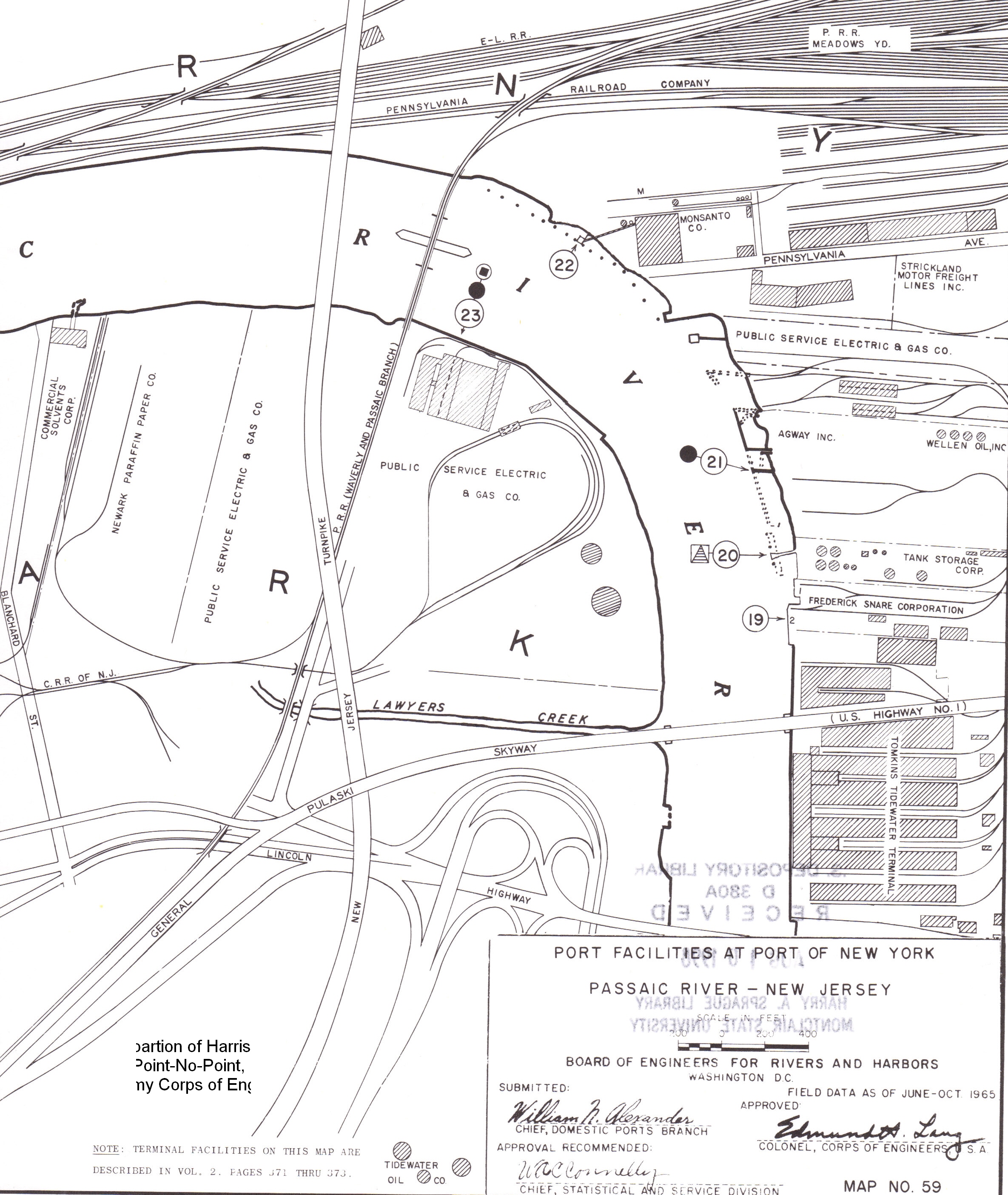
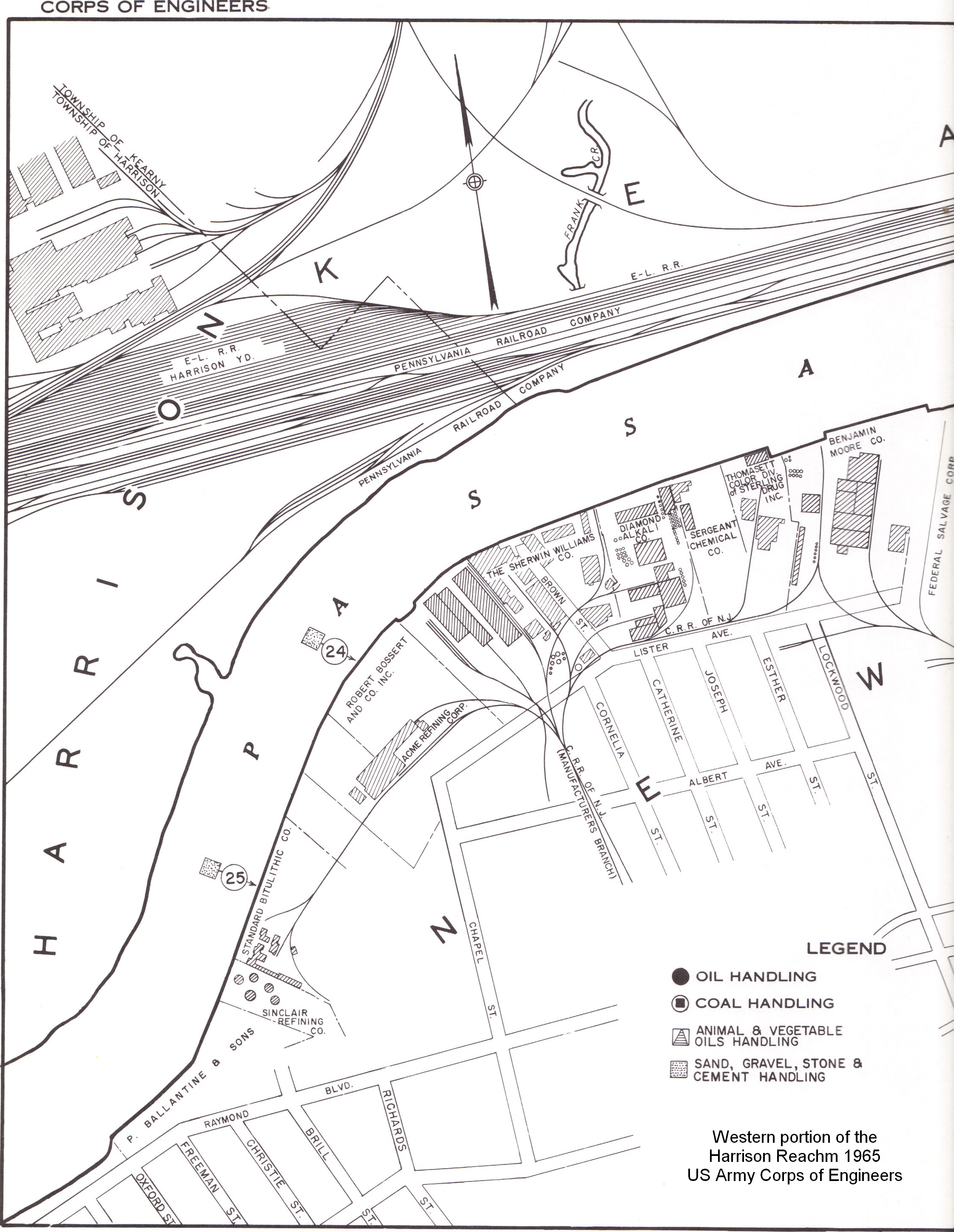
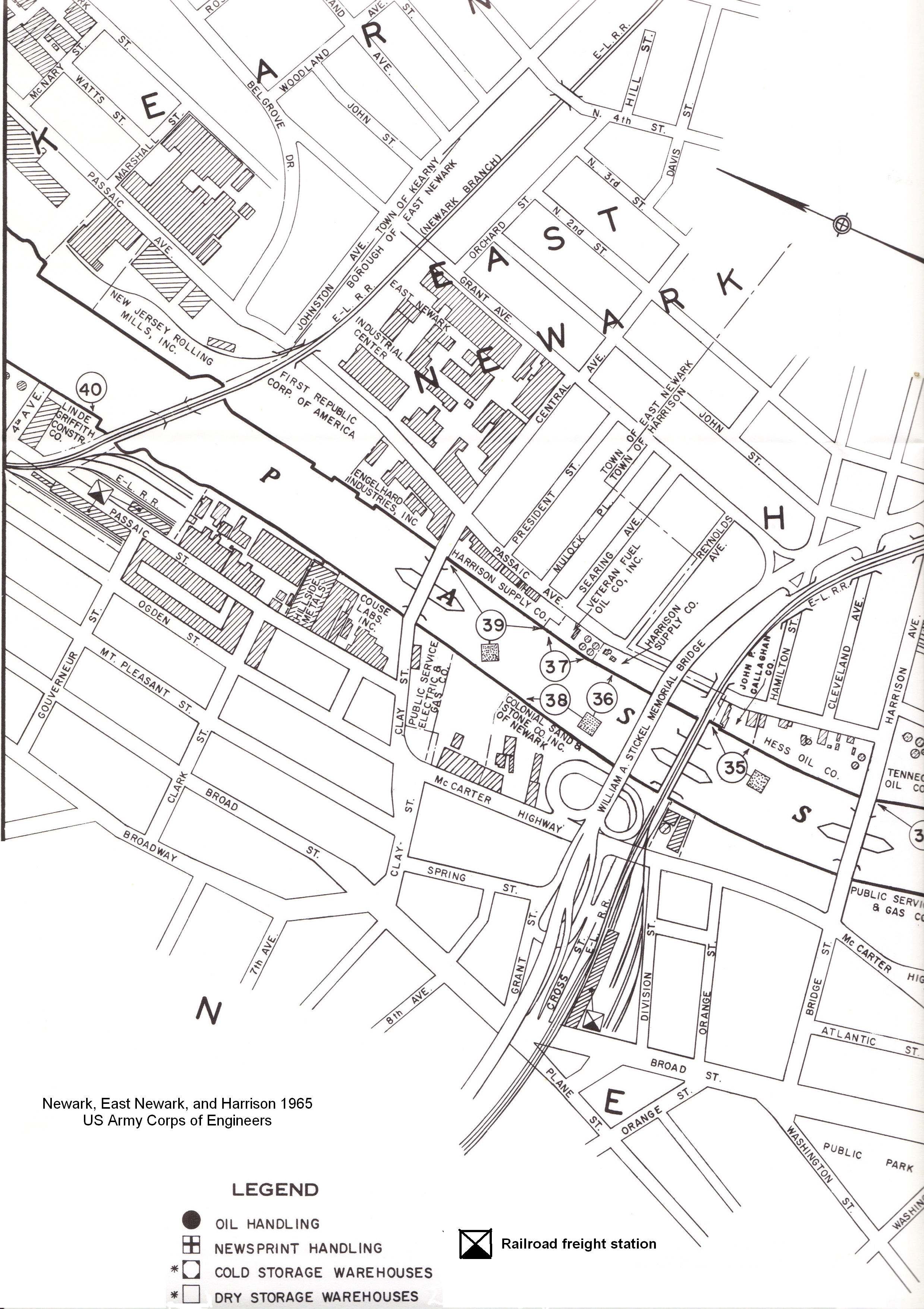
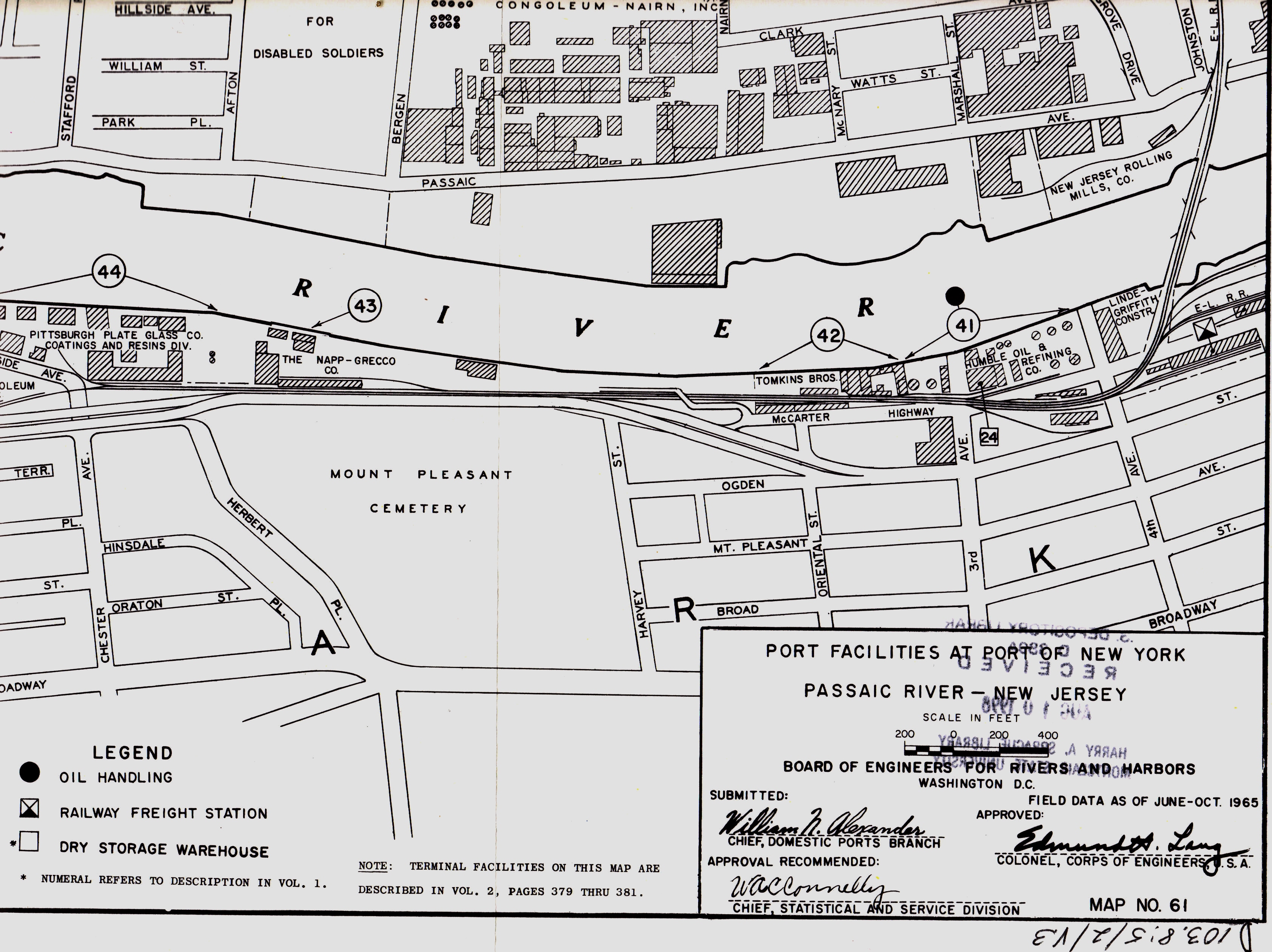
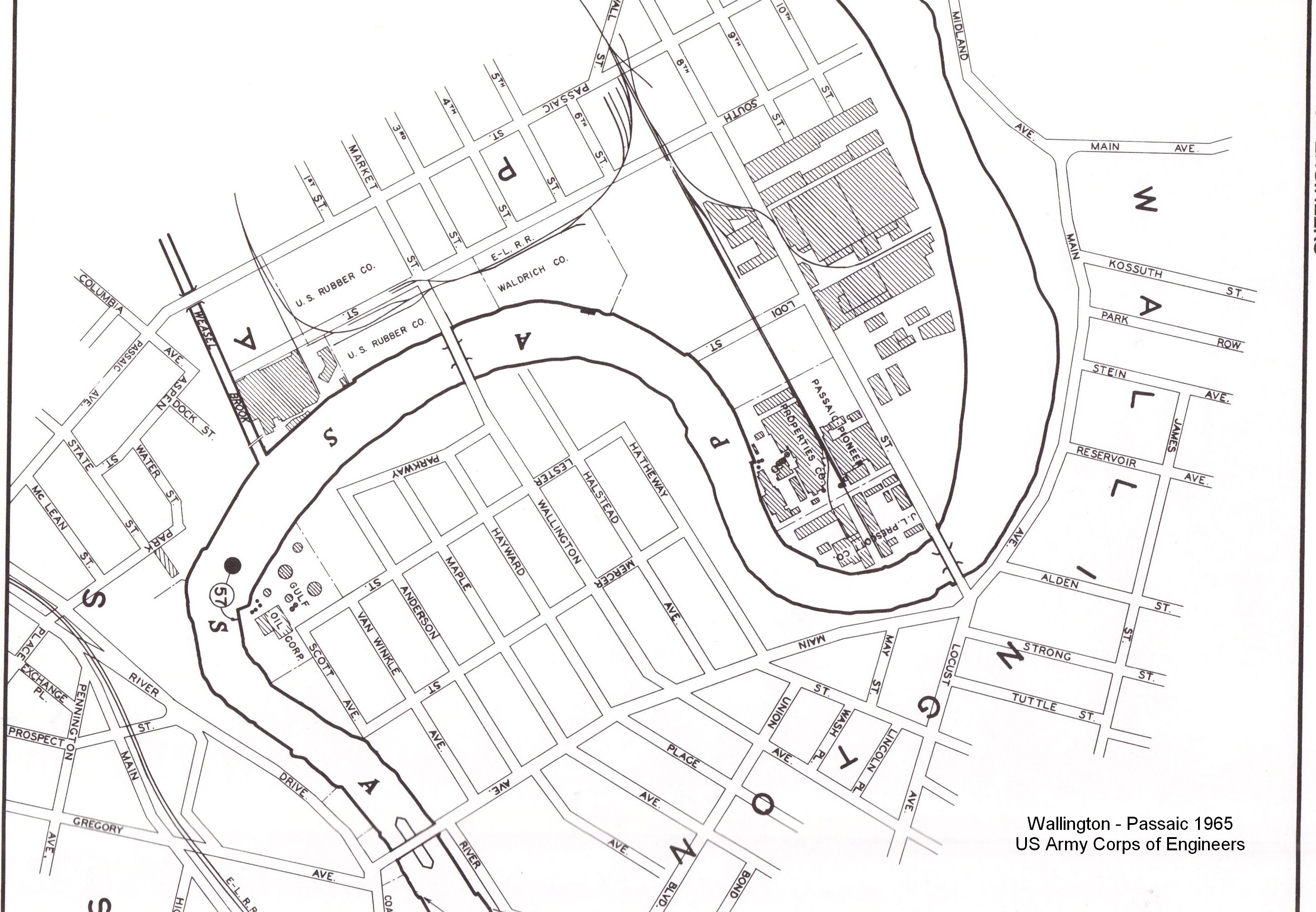